This page is unofficial. It is not affiliated with or endorsed by the E-470 Public Highway Authority.
Above photo: E-470 as viewed looking northbound from the 56th Avenue bridge. The terminal for Denver International Airport is the white blotch on the horizon on the right side of the picture.
![]()
![]()
The E-470 Tollway is a partial beltway around the eastern side of metro Denver. It starts at I-25 Exit 194 in the south side of the metro, goes east through Douglas County to Parker Road (SH 83), then curves north, and goes into Arapahoe County and along Aurora's east side. It intersects I-70 Exit 289 on the Arapahoe/Adams County Line, then goes north past the west side of Denver International Airport. It then drifts northwest across I-76, US 85 and the Platte River south of Brighton, then ends at I-25 Exit 228. It is 46 miles long.
Throughout this page, I refer to separate "segments" of E-470: These segments are:
E-470 is run by the E-470 Public Highway Authority, a consortium of the governments of the jurisdictions the highway passes through (except Denver). It operates under Colorado's Public Highway Authority Act, which is described on the PHA Tollway page. The E-470 Authority was created in February 1985 by an agreement among the counties of Adams, Arapahoe, and Douglas, and the city of Aurora. Later, the cities of Brighton, Commerce City and Thornton joined. The cities of Arvada, Greeley, and Broomfield, plus Weld County, are affiliate, nonvoting members. The Board that directs operations of E-470 is comprised of one representative from each of the voting member jurisdictions. Executive Director of the Authority is Ed DeLozier. Steve Hogan was Executive Director until Fall 1998, when he left to take up the cause of the Northwest Parkway.
The Authority's headquarters are at 22470 East 6th Parkway in Aurora, at the 6th Parkway exit.
As part of the Public Highway Authority Law, the voting jurisdictions have a $10 vehicle registration fee approved by voters. This fee is being used to pay off the bonds and other financing used to build the roadway, so once those are paid off and the tolls are enough to sustain operations, the fee will end. The tolls are also used to pay off the bonds, so the more traffic the tollway gets, the sooner the $10 fee will end.
E-470 grew out of the need for the eastern part of the Denver beltway, but the state wouldn't do it. The state did attempt to build I-470, but then had to scrap that due to opposition and build a scaled-down version, what would eventually become today's C-470. Douglas County was the first place to push hard for the eastern part of the beltway, with the County Board demanding in the mid-1970s that the state build a major highway facility from I-25 to Parker Road. That didn't happen, but in the mid-1980s, Arapahoe County started pushing for a beltway. In 1983, the Arapahoe County Airport Influence Area Transportation Study recommended an eastern half of a beltway be built, and that it connect with C-470 in the south to create an extension of it. A group of landowners organized a public/private coalition to advocate the southeast part of the beltway, labeled "E-470" for Extension 470.
Interest initially was limited to Arapahoe and Douglas counties, but Adams County soon joined. Shortly thereafter, the E-470 Task Force was organized, which included the counties of Adams, Arapahoe, and Douglas. The City of Aurora joined soon after, and in February 1985 the governments signed the intergovernmental agreements to form the E-470 Authority. The Public Highway Authority Act (described here) was passed in late 1987, and then in January 1988 the E-470 Public Highway Authority became a political subdivision of the state. The $10 vehicle registration fee was passed by voters in November 1988, and financing was secured.
Ground breaking was held on Segment I in December 1988, and the 5-mile section from I-25 to Parker Road opened in June 1991. At first Toll Plaza A charged 50�, and was the first tollway in the country to employ high-speed electronic toll collection lanes.
All 10 miles of Segment III from 56th Ave. to 120th Ave., plus the remaining 7 miles of Segment I from Parker to Smoky Hill Road, opened on July 1, 1998. The toll on Plaza A was raised to 75�, but at the same time the Authority allowed drivers to use all of Segment III and the section of Segment I for free. Tolls started being collected October 1, 1998.
All of Segment II opened on May 3, 1999. This was two months ahead of schedule, due to a mild winter which allowed construction to go at a very fast pace. Tolls on Segment II were waived for one month for EXpressToll users.
The E-470 Board approved the budget to start buying out land owners along Segment IV in January 1999.
On July 1, 1999 tolls were increased at various areas of E-470. Ramps booths that had previously charged 25� were increased to 50�, so that all ramp booths charged 50�. Toll Plazas A and D, which previously charged 75� and $1.00, respectively, were each increased by 25�.
In May 2000, a new interchange, Exit 9 at Gartrell Road, opened. The developer at the interchange, US Homes, paid E-470 to keep the toll at the interchange free until the start of 2001, when it would become 75�.
On January 1, 2001, tolls increased several places again. All four plazas went up by 25�, as did the ramp booths at Smoky Hill, Quincy, and Jewell.
On August 8, 2002, a four-mile section of Segment IV opened, from 120th Avenue to US 85.
In October 2002, a new half-diamond interchange, at Chambers Road near Plaza A, opened. The interchange included only a northbound offramp and southbound onramp.
On January 1, 2003, tolls at every mainline plaza went up 25�. This meant Plaza A charged $1.50, while Plazas B, C, and D charged $1.75.
On January 3, 2003 the remaining portion of Segment IV, from US 85 to I-25, opened. The segment included Plaza E, charging $1.75, but EXpressToll users could use it free for one month.
On November 24, 2003, the connection through the north I-25
interchange opened to the Northwest Parkway.
On May 13, 2004, new ramps at Jamaica Street opened. A northbound
onramp and southbound offramp allow better access to Park Meadows Mall
and the Meridian and Inverness office parks.
On November 22, 2004, the remaining two ramps at the Chambers Road
interchange opened, turning it into a full diamond interchange.
On January 1, 2006, tolls at every mainline plaza went up 25�.
Thus Plaza A charged $1.75 and all other plazas charged $2. Also, any
ramp booth that was at 50� was increased to 75� so all ramp
booths on the whole corridor charged 75�.
On July 11, 2006, the southbound side of the "Flyby" bypass at the
I-70 interchange opened. The northbound side opened on August 24, 2006.
The "Flyby" allows E-470 through traffic at I-70 to bypass the four
signals it previously had to go through.
On October 25, 2007, the flyover at the I-70 interchange opened. It
forms a direct connection for northbound E-470 to westbound I-70
traffic, bypassing the signals within the interchange.
On January 1, 2009, the toll structure went through a major overhaul
in preparation for E-470 moving to cashless operation. All tolls were
increased and a tiered toll structure was introduced, with ExpressToll
users paying less than cash/license plate reader users. The mainline
toll plazas saw their tolls go up 25� for ExpressToll and 50�
for cash/license plates. Plaza A became $2.00/$2.25 and other mainline
plazas became $2.25/$2.50. All ramp booths increased to $0.90/$1.00.
All tolling also started including the option for license plate
reading, in which a car could not pay and instead a photo would be
taken of its license plate and a bill for the toll mailed to the owner.
For non-ExpressToll users, this meant they no longer had to stop at a
booth and pay cash (but they still could), instead they could speed
through the ExpressToll lanes at highway speed. This basically meant
there no longer was any such thing as a toll violation. Instead you'd
just be billed for the toll. Previously, a non-ExpressToll user not
stopping to pay cash would have been charged with a violation.
On January 1, 2011, the E-470 impelemented another of the scheduled
toll increases. Plaza A became $2.15/$2.70, other mainline plazas went
to $2.40/$3.00 and ramp booths changed to 95�/$1.20.
On June 9, 2011, the E-470 board approved increading the speed limit
on the tollway from 70 mph to 75 mph. Crews immediately changed the
signs. The change followed a speed study on the road that showed most
drivers were already going 75 mph, plus installation of median cable
barrier was recently done to prevent median crossover accidents.
Several curves were only designed for 70 mph however, and got advisory
speed warning signs.
On January 1, 2012 E-470 imlplemented its latest toll increase. Plaza A became $2.25/$2.80, other mainline plazas $2.50/$3.15 and ramp booths $1/$1.25.
On January 1, 2013 E-470 imlplemented its latest toll increase.
Plaza A became $2.35/$2.95, other mainline plazas $2.60/$3.25 and ramp
booths $1.05/$1.30.
On January 1, 2014 E-470 imlplemented its latest toll increase. Plaza A became $2.45/$3.05, other mainline plazas $2.70/$3.40 and ramp booths $1.10/$1.40.
On November 24, 2014, the Quebec Street interchange opened. The ramp tolls were waived until January 1, 2015.
On January 1, 2015 E-470 imlplemented its latest toll increase. Plaza A became $2.50/$3.15, other mainline plazas $2.75/$3.45 and ramp booths $1.15/$1.45.
The E-470 Tollway is built to freeway standards. There is a median separating two to three lanes in each direction, and the speed limit is set to 75 mph with a 50 mph minimum. Tolls are collected via five mainline electronic toll plazas. There are on- and offramps like any normal freeway, but some of them have single electronic toll booths. Exit numbering is done via the milepost method, with the zero point being I-25 in the south. It's paved with asphalt, except at the toll plazas which use concrete.
The toll authority has employed a coloring scheme that is on all the bridges, and the main color is beige, with the top of the railing being red. Over- and underpasses are marked in an interesting way. If you're on E-470 and there is a road using an overpass over E-470, the name of the cross street is etched into the bridge just to the right of the abutment up and to the right of the driving lanes. When on a surface street crossing under E-470, there is a large E-470 sign on the bridge.
E-470 also is heavy into the concept of intelligent transportation systems. There is a fiber optic backbone which runs the length of the tollway, which is used for all of the electronic needs of the tollway, including toll collection, camera enforcement, etc. Be sure to read below how EXpressToll transponders are recorded at high speed.
Yikes, That's Expensive!
Yes, E-470 is an expensive toll road to drive along. The tolls are the
chief way of paying off the bonds that were used to build the road. The
final construction cost for the 46 miles of road was around $2 billion,
so bonds, when you add interest, in excess of that had to be sold. The
finance plan to service the bond debt was approved in 1990 and has
regulary scheduled toll increases, as the plan included increasing debt
payments as time went along.
E-470 does not receive gas tax revenue. Also some people say "Why
aren't the tolls around the same as East Coast toll roads?" That's not
an apples-to-apples comparison. Northeast toll roads date to the 1950s
or earlier and so have long ago paid off their construction costs.
Their tolls only need to fund ongoing operations, not service original
construction bond debt.
Toll Options
Mainline Toll Plazas
E-470 has five mainline electronic
toll
plazas where vehicles pass through at highway speed. ExpressToll
transponders are read or a picture of the license plate taken for
bill-by-mail. Previous to cashless option, mainline toll plazas had
five lanes. The two to the left were 70 mph lanes for ExpressToll
users. Three lanes to the right had booths staffed with E-470
employees,
and there motorists could elect to pay
with cash and coins.
Toll Plaza A
Located between Peoria St. and Chambers Rd.
ExpressToll users: $2.50
License plate reader users: $3.15
Each additional axle at the above rate
Toll Plaza B
Located between Quincy Ave. and Jewell Ave.
ExpressToll users: $2.75
License plate reader users: $3.45
Each additional axle at the above rate
Toll Plaza C
Located between I-70 and 56th Ave.
ExpressToll users: $2.75
License plate reader users: $3.45
Each additional axle at the above rate
Toll Plaza D
Located between Pe�a Blvd. and 96th Ave.
ExpressToll users: $2.75
License plate reader users: $3.45
Each additional axle at the above rate
Toll Plaza E
Located between between US 85 and Quebec St.
ExpressToll users: $2.75
License plate reader users: $3.45
Each additional axle at the above rate
Ramp Booths
There are also single electronic toll booths at selected
exit/entrance ramps, so you still have to pay if you get on "after" a
toll plaza or get off "before" a toll plaza. These ramp booths charge $1.15 for ExpressToll
users and $1.45 for license plate reader users. Go to the "Guide"
section further down this
page to get the exact listing of which ramps have ramp booths, or see
my E-470 exit list.
Prior to cashless operation, the ramp booths featured a coin basket for non-ExpressToll users. They were just small
structures that you throw change in a basket, a light turns green,
and you continue on. Being that they were
unstaffed, they
were capable of only accepting coins, not bills. Many of the ramp booths along E-470 had a two-lane setup, with the left
lane has the booth for collecting coins while the right lane was an
ExpressToll lane. This allowed ExpressToll users to not have to stop if
there was someone at the booth depositing coins.
EXpressToll Transponders
EXpressToll has been mentioned throughout this page. EXpressToll
is an electronic toll collection system, using a radio transponder
attached to a vehicle's windshield. It's like the I-Pass system in
Chicago or EZ Pass in the Northeast. EXpressTolls will also be recorded
when a
person uses a ramp booth. The transponder is either a 3" x 4"
wallet-sized unit, or if newer a small sticker with an embedded
computer chip.
When an EXpressToll user is detected, the system deducts the toll from the user's account. Early versions of the transponders would beep to let the driver know the toll was logged, however current versions don't beep. An account is opened with $35 from a credit card, and the user's vehicle, license plate, and driver's license number are entered into the system. Whenever the account drops to $10, additional funds are automatically added to the account from a credit card. One can apply at the EXpressToll site, call 1-888-9-GO-E470 (1-888-946-3470) or get a transponder in person at the Authority's headquarters at 22470 East 6th Pkwy. (E-470 at the 6th Parkway exit).
How the high-speed EXpressToll lanes work at the mainline plazas is quite amazing. As a car approaches, it breaks a light beam across the highway which triggers the system. More light sensors read the vehicle's horizontal and vertical profiles, treads running across the pavement count the number of axles, and a radio system receives the signal from the transponder in the vehicle. If the transponder says the vehicle should be such-and-such and it matches with what the outside sensors read, then the toll is deducted from the user's account. If the transponder does not match with what the outside sensor's read, cameras take pictures of the license plate. If a vehicle goes through the high-speed lanes and a transponder isn't in the vehicle, the same thing happens. E-470 was the first tollway in the country to have dedicated, high speed electronic toll collection lanes in the country when it opened in 1991.
Historical Note: Toll Violations
Before January 1,
2009, E-470 didn't have the license plate reader system, so going
through the ExpressToll lanes without a transponder was a toll
violation. First-time toll violators were charged a $25 "administration
fee", but no
points were assessed against a driver's license. Repeat offenders were
fined $47 plus the toll. At ramp booths, if a driver didn't have exact
change, one could take an Insufficient Funds Form, located in a box
on the booth, and avoid a toll violation by mailing in the toll payment
within 48 hours. But with the advent of the license plate bill-by-mail
system, non-ExpressToll users were simply mailed the bill rather than a
violation.
Segment I: I-25 to Smoky Hill Road
Segment I of E-470 was the very first segment to open, in 1991.
However, not the whole segment opened, instead only the section from
I-25 to Parker Road. Detractors quickly dubbed E-470 the "Road to
Nowhere", because at that time it actually did go nowhere in
particular. Little did they know that in another eight years it would
become a "Road to Somewhere". The eastern end of Segment I, from
Parker Road to Smoky Hill Road, opened on July 1, 1998.
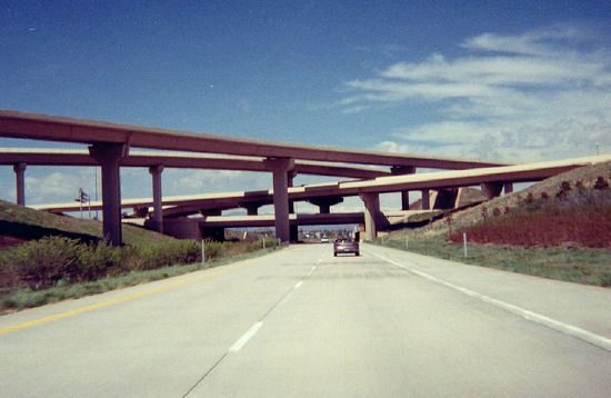
E-470 starts at a sprawling, four-level interchange at I-25 Exit 194 near Lone Tree (picture, taken on westbound E-470). The interchange connects I-25, E-470, and SH-470. I call it a "stack" interchange, and it is good in that it allows drivers to go from any roadway to another without having to take a tight, cloverleaf-style ramp. Westbound through traffic on E-470 takes the lowest level of the stack and continues west on SH-470. To get to I-25, westbound traffic exits off to the right, then either takes the right ramp (Exit 1A) to I-25 north or a flyover (Exit 1B) to I-25 south.
From I-25, E-470 goes east through Douglas County just south of the Arapahoe County Line. Off to the south side of E-470 just east of I-25 is the Meridian Office Park, one of those "office campuses" that are so popular nowadays. The Inverness Office Park is north of E-470. Both are served by E-470's first exit, the Jamaica Street interchange. However, it is only a half diamond, with a northbound onramp and southbound offramp. The Jamaica ramps opened on May 13, 2004, after Douglas County put up funding to build them.
The next interchange, Exit 2, is at Peoria Street. Heading south
on it, one can get to Meridian Office Park, while
northward it goes to Centennial Airport. The northbound offramp and
southbound onramp have ramp toll booths. The other two ramps are free.
East of Peoria, at about Milepost 2.5, E-470 hits Toll Plaza A.
This plaza charges $2.50 for ExpressToll and $3.15 for license
plate reader. Additional axles are at the same rate. When it first
opened, however, it charged 50�, and had an
automatic booth on the left side where you could throw change in a
basket. The increase to 75� was supposed to go into effect in
1995, but was instead put in place on July 1, 1998. The automatic
booths were then also converted to staffed booths.
The next thing east is a diamond interchange at Chambers Road (Exit 3). The ramp tolls are on the southbound off- and northbound onramps. The bridge was there since E-470 opened, but Chambers Road didn't exist over the freeway until 2002. Two of the ramps, northbound off- and southbound onramps, opened in November 2002, with the other two ramps opening November 2004.
Now comes the next interchange, Exit 4 at Jordan Road. Jordan
Road
is an important link from Lincoln Ave. up northwest to the Denver
Tech Center, and gets lots of commuter traffic. Ramp booths are on the northbound
onramp and the southbound offramp, with
the other two ramps being free.
Next interchange is Exit 5. This is SH-83, a.k.a. Parker Road, a multilane expressway from Denver's rapidly growing southeast area into town. This is a totally free interchange; there are no ramp booths. It is a partial cloverleaf interchange, which includes cloverleaf-style direct ramps from NB Parker to SB E-470 and SB Parker to NB E-470. To get from E-470 to Parker, there is just one ramp for each direction, and then you turn right or left at the signal lights at the bottom.
When Segment I first opened in 1991, E-470 ended at Parker until more sections opened in July 1998. At first, it was just a standard T-intersection. However, as the second part to Smoky Hill Road was constructed, the interchange was constructed. Evidence of this can be seen in the photo gallery, with the sign that says "E-470 WEST, RIGHT 1/2 MILE". Before the interchange was constructed, drivers on NB Parker turned left to go on WB E-470, but after construction took a ramp off to the right.
East of Parker Road, E-470 changes direction, curving from east to north and also climbing up out of the Cherry Creek valley. There is not really anything for a few miles except for crossing from Douglas County into Arapahoe County, and some weaving in between housing developments with an underpass at Ireland Way. But at Milepost 9, there is Exit 9 at Gartrell Road. Gartrell was a totally new street constructed out basically in the middle of nowhere. The interchange opened in May 2000. According to the February 23, 1999 Rocky Mountain News, a massive $135M development is going to go in, featuring 600,000 sq. ft. of office space and 300,000 sq. ft. of retail space. It will go in on all four corners of the new interchange. The interchange has ramp booths on the northbound off- and southbound onramps. When the interchange first opened in May 2000, the booths were free for 8 months, because the developer, US Homes, paid the Authority to keep them free.
E-470 hits Smoky Hill Road at Exit 10. Ramp booths are on the northbound offramp and southbound onramp. This interchange was the end of Segment I from July 1, 1998 to May 3, 1999, so all northbound traffic had to exit and go through the single ramp booth. The ramp booths temporarily were free from July 1 to October 1, 1998, so when the tolls started being collected a bottle neck formed on October 1 and tempers flared. Attendants came and waved people through for a couple of hours to ease the log jam, and the Authority blamed the drivers for not being prepared to pay the toll. It was only two quarters, after all. This prompted a couple of angry letters to the editor, blaming the Authority for not having more than one lane through that booth. (Author's feelings: It's just a regular ramp booth, so there's nothing wrong with it having only one lane. Besides, the backups disappeared when the section north of Smoky Hill opened.)
Segment II: Smoky Hill Road to 56th Avenue
With the opening of this section on May 3, 1999, the E-470
Tollway finally had the capability of being truly useful, allowing
drivers to go from the southeast metro to I-70 and DIA in about 20
minutes. It's a wonder they didn't construct this section second,
instead of Segment III.
One mile north of Quincy, there is an underpass at Hampden Ave. North of Hampden, at Milepost 15, E-470 hits Plaza B. This plaza charges $2.75 for ExpressToll and $3.45 for license plate reader, and additional axles at the same rate.
North of Plaza B, E-470 intersects Jewell Avenue at Exit 16. Ramp booths are on the northbound on- and southbound offramps. Jewell here was a totally new street, part of the "Jewell-Iliff Extension" that was built from Gun Club Road west to Tower Road. The section from Gun Club west to E-470 was built first, so if a driver got off E-470 at Jewell, all they could do was go east to Gun Club. The stretch west to Tower opened later.
When Segment II first opened, the Jewell Ave. exit was not open right away. The Authority said bad weather delayed the last stages of construction, so changeable message signs on the Tollway said "Jewell Ave. Closed Use 6th". However, the Jewell exit was open a week later, and the CMSs were changed to say "Jewell Ave. Open to Gun Club".
North of Jewell Ave. arises an issue that is sure to be the cause of some grumbling: There is no interchange, only an underpass, at SH 30. Robert Halonen let his feelings be known to me in an e-mail from November 1998:
I'm still bitter there will not be an interchange at SH 30. That makes E470 useless to people commuting to Centretech Business Park or Buckley Air National Guard Base; two areas I would think would be hot destinations. Instead they are building interchanges at the non-existant Jewell Av and 6th Av. The former may have some use serving a residential area, but there's nothing but horse farms near the latter!
SH 30 is a fairly busy highway. It runs north along Gun Club from Quincy, then north of Jewell it starts curving to the northwest, goes past Buckley Air Force Base, then curves west onto 6th Ave. into the main part of Aurora. As Aurora grows more out to the east, SH 30 will get more and more traffic as people need to head from that area into Aurora and Denver. As it stands now, the easiest way to get between E-470 and SH 30 west into Aurora is to exit at Jewell and take that east to Gun Club Road, then go north.
North of all that, the next interchange, Exit 19, is at 6th
Parkway. Don't let the "Parkway" fool you; all it is is a two lane
road built westward from Gun Club Road, through the E-470
interchange, ending west of E-470 at the E-470 Public Highway
Authority Headquarters. The exit has ramp booths
on the southbound off- and northbound onramps.
The 6th Parkway exit
exists pretty much simply to serve the Authority's headquarters. One
can go there to get EXpressToll transponders, and advertising that
fact are blue signs before the exit which say "EXpressToll Service
Center".
Finally, we reach I-70 at Milepost 20. However, it is not a full freeway-to-freeway interchange.
Most movements getting between E-470 and I-70 utilize what is the old Gun Club Road
diamond interchange on I-70. From E-470, ramps take traffic down to the
old Gun Club Road alignment east of E-470 to head either direction on
I-70. Old Gun Club Road features four sets of signals around I-70: 1)
Colfax Ave (I-70 south frontage road), 2) I-70 eastbound ramps, 3) I-70
westbound ramps and 4) 19th Ave & Smith Way. While old Gun Club
Road feeds traffic to and from I-70, through traffic on E-470 is on a
"flyby" bypass just to the west of Gun Club.
The exception to ramp traffic needing to use the signals is the
direct flyover from northbound E-470 to westbound I-70. It is the
heaviest left-turn movement in the interchange and while traffic was
still using the old Gun Club Road interchange, backups in the morning
were common. The flyover bridge, which is two lanes wide and 1600 feet
long, crosses over both I-70 and E-470 as the third level of the
interchange. The merge from the flyover onto westbound I-70 features a
barrier keeping it separated from I-70 for a while to prevent drivers
from trying to swerve across three lanes of traffic to get to the left
exit from I-70 to Colfax.
Through traffic on E-470 being on the flyby is a major improvement over when E-470 first opened. In 1999 when it opened, E-470
warped from a freeway down to Gun Club Road and used the diamond
interchange and Gun Club Road overpass for through traffic. One
went from blazing happily along at 70 mph to a 45 mph zone and a
screeching halt at one or more of the four signal lights. All of the
tollway traffic mightily taxed the old Gun Club Road interchange.
As to why that situation existed when E-470 first opened, that was finally explained in some detail in the May 24, 1999 Rocky Mountain News. The problem came about because E-470 was originally supposed to intersect I-70 about 1.5 mi further to the east. However, financiers of the roadway feared that E-470 being that far east would cause drivers to choose Gun Club Road instead, causing there to be almost no toll revenue. Thus, E-470 was rerouted further west along Gun Club to eliminate that possibility. According to former Authority Executive Director Steve Hogan, "By late 1991, the whole project was near death and on life support. A number of analyses determined the only way the project was going to be built was if the road was moved closer in to the metropolitan area. Otherwise, it was unfinanceable." As for the at grade intersections, even with the financiers on board, there still was not enough money to build an interchange with the flyovers and ramps. Hogan went on to say, "It came down to a question of what would be acceptable to the federal and Colorado highway departments, which have the final say on Interstate interchanges. They wanted either an ultimate interchange or what we ended up doing -- and nothing in between. They were concerned if something was built in between and ran out of money, they would be stuck building the ultimate interchange. We had no choice." Current Executive Director Ed DeLozier chimed in: "We don't like [the signal lights] either. But it's just an interim solution. The plan is to get rid of the lights as soon as possible."
"As soon as possible" turned out to be 2006. Construction on the
flyby bypass, to get E-470 through traffic out of the signal lights,
began in January 2005. The southbound side of the flyby opened July 11,
2006 and the northbound side opened August 24, 2006. On October 25, 2007, the flyover opened. At some point in
the future, a multi-level full freeway-to-freeway
interchange will be built at I-70 and E-470.
North of I-70, E-470 continues north and has on overpass over Smith Road, which also goes over a railway on Smith Road's immediate north side. Next, there is also an underpass at 26th Avenue. North of 26th, E-470 goes through Plaza C. Like Plaza B, this plaza charges $2.75 for ExpressToll and $3.45 for license plate reader, and additional axles at the same rate. North of Plaza C is an underpass at 48th Avenue. At Exit 24, E-470 intersects 56th Avenue, and Segment II ends.
Segment III: 56th Avenue to 120th Avenue
Segment III was the second part of E-470 to open, on July 1,
1998. When it did, since Segment II had not yet opened, Segment III
was off all by its lonesome self in the northeast part of the metro.
It linked to Pe�a Blvd. and thus DIA, but since it didn't go
anywhere else when it opened, it wasn't very useful, except for
people going from the Brighton area to DIA.
When Segment III opened, the Authority let people drive on it free until October 1, 1998. Toll Plaza D, plus all of the ramp booths, were free when the section first opened to encourage people to use it. "The free period is a way of saying thank you to our current users and to give people the opportunity to get used to the tollway and see how fast and safe it is," said Aurora Mayor Paul Tauer, chairman of the E-470 Board of Directors. Changeable message signs said things to the effect of "TOLL FREE / ENJOY THE RIDE". And a lot of people did. When it first opened, traffic was fairly heavy, but once the toll started being collected, the segment was nearly deserted when I was on it. For example, Airport Express, which is a shuttle bus service that transports people between DIA and Longmont, Loveland, and Fort Collins, had its buses use E-470 when it first opened, but as soon as the toll started being collected, the company no longer used it, instead using Tower Road as they had before.
Anyway, 56th Avenue is at Exit 24, and has ramp booths on the southbound off- and northbound onramps. 56th accesses some businesses to the west as well as the DIA employee parking lot and some park-n-pay lots, so can get fairly busy at rush hours, consequently there are poles at the ramps on 56th in place to allow signal lights to be put in in the future. 56th was the south end of Segment III when it opened, and traffic could not go further south. As a result, all southbound traffic was channeled onto the offramp.
Between 56th and Pe�a Blvd. E-470 curves west and then
north again, and along the way hits 64th Avenue at Exit 25. That
interchange, like 56th, has ramp booths on the southbound off- and
northbound onramps. North of 64th, E-470 has a section
that while one is on northbound E-470, is pointing almost due west. It
is one of the highest points in the area and affords a great view of the
Front Range mountains to the west.
The Pe�a Boulevard interchange is Exit 28. The Authority started off with a standard cloverleaf, but then augmented it with some collector/distributor ramps. Going northbound, it's like a standard cloverleaf, where you take the first ramp to get to eastbound Pe�a and DIA, and then take the second loop ramp to get to WB Pe�a. Going southbound, however, one first breaks off onto a separated collector-distributor roadway, then takes the first ramp for WB Pe�a and the second ramp for EB. The separated roadway starts off as a two-lane exit, but then one of the lanes ends in between the first and second ramps.
The southbound separated roadway apparently confused some people at first. When I went through in July 1998, two weeks after it had opened, one driver was trying to get to DIA, but didn't take the exit they were supposed to to get onto the separated roadway. When they realized they were going to miss the exit to EB Pe�a, they suddenly slammed on the brakes, drove over onto the shoulder, off the pavement, across the grass, and then onto the separated roadway to get to the loop ramp.
Another issue of confusion concerns what signs say about E-470 on Pe�a Blvd. Before Segment II opened, if one headed south one could only get as far as 56th Ave., so the signs for South E-470 said "TO 56th AVE". That made sense. However, now that one can go farther south than 56th, the signs have been changed to read "TO I-70". It's been a recipe for confusion, because when drivers coming out of DIA see that, they think they have to use E-470 to get to I-70 and Denver, when in fact they can just continue straight ahead on Pe�a. Additional signs have been added to Pe�a to deal with it.
North of Pe�a, E-470 goes through Plaza D, charging $2.75 for ExpressToll and $3.45 for license plate reader, and additional axles at the same rate. Since this plaza was free for three months when it first opened, traffic was diverted onto the EXpressToll lanes so everyone could go flying through.
One of the toll schedule signs on NB E-470 approaching Plaza D in January 1999 had duct tape covering over all of the prices. When I reached the Plaza, I told the attendant this, saying it looked like the sign had been vandalized or something. The attendant said actually the Authority had put the duct tape over the prices because the contractor that made the sign had made it with the wrong prices on it. Oops!!!
Less than a mile north of Plaza D, E-470 hits the 96th Avenue interchange at Exit 31. There are booths on the southbound off- and northbound onramps. North of that, there is the 104th Avenue interchange at Exit 32. Once again, the southbound off- and northbound onramps have ramp booths. 104th is quite busy with cross-metro DIA-bound traffic west of Tower Rd., but east of that is pretty much deserted. Both 96th and 104th have Commerce City North Range as a secondary destination, and 104th has a secondary destination of Buffalo Run Golf Course.
North of 104th, E-470 curves west then north, crossing under 112th Ave. and Tower Rd. along the way. At 120th Avenue, there is another diamond interchange (Exit 34). Again, the northbound on- and southbound offramps have ramp booths. 120th serves as a connection from I-76 to E-470, since a little further northwest the I-76/E-470 interchange is only partially complete.
Prior to August 2002 the Tollway ended at an at-grade intersection at 120th Ave. Approaching it from the south, the destination distance signs in the median had large, yellow "TOLLWAY ENDS" plaques next to the 120th Ave. listing. A half mile before it, there was an overhead sign announcing the tollway was about to end at signal lights, with yellow flashing lights. The divided highway ended, and finally one hit 120th at a T intersection with signal lights.
Segment IV: 120th Avenue to I-25
In Spring 1999, the Authority had begun the eminent domain
process to buy out landowners along the stretch. In early 2000, a
design-build contractor, MKK Construction, was chosen. In May 2000,
bond funding was secured. Construction began September 2000. The
first subsection of Segment IV, from 120th to US 85, opened on August
8, 2002. The remainder, from US 85 to I-25 opened January 3, 2003.
Between August and January northbound traffic was channeled onto the
offramp at US 85.
Construction of Segment IV was almost delayed due to a lawsuit brought against E-470. The City of Golden, Sierra Club, and Colorado Public Interest Research Group sued to force E-470 to do a full environmental impact study of Segment IV. Normally it wouldn't be done because no federal funding was being used for the project. It could have delayed Segment IV by two years, but in the end the suit didn't go to trial.
From 120th E-470 goes northwest toward I-76. At I-76 (Exit 35), only part of the interchange has been built. The only ramp movements available are northbound E-470 to eastbound I-76, and westbound I-76 to southbound E-470. All other movements need to use 120th Avenue. The WB to SB movement is done with a large-radius loop ramp, while the NB-EB movement is done with a ramp that soars over the rail line that runs adjacent to I-76 south side. There are no tolls at the I-76 interchange.
From I-76, E-470 continues northwest, crossing under Sable Boulevard (SH 2) and then approaching the US 85 complex (Exit 38), which is actually made up of two separate interchanges. There is a trumpet interchange on E-470, and after exiting there a driver goes south on a short connecting road (formerly Nome Street) to a diamond interchange at US 85. There is a ramp toll booth on the connecting road.
Northwest of US 85, there is an overpass which takes Brighton Road over E-470, and then E-470 uses a long, flat bridge to cross the South Platte River. There is an overpass at Riverdale Road, and then E-470 comes to Plaza E at Milepost 39. It charges $2.75 for ExpressToll and $3.45 for license plate reader, and additional axles at the same rate. When this portion of Segment IV first opened, the Authority let EXpressToll users use it for free.
Northwest of the plaza, E-470 climbs up a grade and out of the
Platte River valley, and then meets the Quebec Street interchange (Exit
41), which has ramp booths on the northbound on- and southbound
offramps.
When E-470 was first built the Quebec Street overpass was put in but no
interchange ramps. The interchange was put in and opened on November
24, 2014 as development slowly marched north.
Next thing northwest is the interchange at Colorado Boulevard (Exit 43), where one can easily access Thornton's northern fringe. Ramp booths are in place on the northbound on- and southbound offramps . E-470 then has an interchange with York Street (Exit 45), where again ramp booths are in place on the northbound on- and southbound offramps.
After York Street, E-470 approaches the northern I-25 interchange. It is a four-level stack just like the southern I-25 interchange. On northbound E-470, one exits off to the right and then takes a ramp to the right or a flyover to the left to I-25. Traffic that remains on E-470 through the interchange ends up westbound on the Northwest Parkway, heading toward Broomfield.
Thus ends your journey on Denver's eastern beltway.
![]()
Continue:
Last updated 8 February 2015