Colorado Highways:
Route Markers Through the Years
State Route Markers
|

|
Here's a porcelain marker for SH 82, put up by Rocky
Mountain Motorists Inc. (local precursor to AAA), probably
from the 1920s. The gray spot in the middle is a bullet
mark. Photo image courtesy George Sammeth.
|
|

|

|
Two versions of a larger porcelain sign. One is from SH 10 (today's US 160) that
was in the town of Mancos. Note the SH 10 marker in the
upper left, the Rocky Mountain Motorists Inc. logo in the
upper right, and distances to various towns. Probably also
dates from the 1920s. The other is from SH 11
(today's SH 131) at State Bridge. What cool signs! Photo images courtesy
George Sammeth.
|
|

|
A blowup of the Rocky Mountain Motorists Inc. logo from
the SH 10 sign above.
|
|

|
This
is the marker that was apparently used up until sometime in the 1930s.
The numbers are in the old-style "block" font. Photo from Scott Broady
via Lary Brown.
|
|
|
 

|
These are photos of markers which apparently
started appearing in the 1930s. The "COLORADO" is embossed
while the number is painted on. This marker uses the modern rounded
font, rather than the older-style block font shown above. The two-digit version uses the FHWA Series D
font, while the three-digit version uses Series C. SH 90 is from 1939,
sent in by Lary Brown. SH 371 is from Michael Summa. SH 789 from Lary Brown.
|
|
|
|
 
|
Sometime in between 1956 and 1964, according to
Colorado MUTCDs I've found at the Denver library, the route marker was
changed to this. "COLORADO" was shortened to "COLO", and the font for the
digits was changed. It was some kind of modified Series D that I can
only call Series D Super Phat, because the stroke width is wider than
usual. According to Michael Summa, on 18" markers two-digit signs had 8"
digits while three-digit signs were 6". SH 96 photo by Steve Riner, SH 144
by Michael Summa. |
|
|
|
 

|
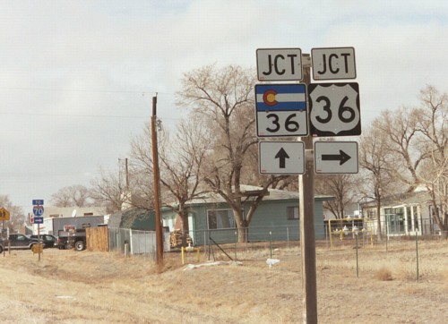
The modern Colorado state highway marker. The emblem
in the top half of the marker is a replica of the Colorado state flag,
which has two blue bars and a red C with a sun inside it. Today the
marker generally uses the Series E font for the
digits, though there are three-digit markers out there with Series D.
Some places you might also see an extra-wide marker for 3-digit routes.
Photos by me.
This version of the marker was rolled out in summer 1967. An article I found in the September 17, 1967 Denver Post
says CDH started using the marker that summer as part of implementing
reflectorized signs as well being more attractive than the white and
black ones used before. "We've always called it Colorful Colorado, and
yet we've had a very drab highway marker," said A. R. Pepper, the state
traffic engineer. Two hundred markers were deployed in some areas
around the state that summer to test them and get public feedback
before they were adopted statewide.
|
US and Interstate Route Markers
|

|
This is the US highway marker first used in Colorado.
This was the marker used across the US for the US highways
when the system was first developed in 1926. Photo by Dale
Sanderson.
|
|

|
A photo of a "cutout" style US highway marker, which
is standard in California. For a time during the late 1950s to 1970s
(and possibly into the 1980s), Colorado used this marker as the
"reassurance" marker and on high speed highways. Photo by me.
|
|

|
Colorado uses the same modern US highway marker that
does most of the US. This marker started being used in Colorado in
marker assemblies during the 1960s, and became the standard sometime
after 1968. Today the marker generally uses FHWA Series D for the
digits. Three-digit markers are rectangular, rather than square. Photo
by me. |


|
Colorado uses the same modern Interstate
marker as does generally all of the US. The differences from one state
to another usually involves whether the state name is included in the
marker. By default in the 2003 national MUTCD the no state name marker
is the norm, while including the state name is allowed as an option. In
Colorado, the state supplement to the national MUTCD does not address
the issue. However, the state Standard Highway Signs book shows
the marker with the state name as default, but says in a note that
COLORADO is included only as part of signing on the mainline and is not
required elsewhere.
Bottom line: COLORADO being included in the Interstate marker is
hit-and-miss. Since CDOT generally farms out signing to contractors as
part of resigning and repaving projects, whether or not COLORADO is in
the marker probably depends on the contractor and who happens to be
running the sign machine. Both photos by me.
Related site: AARoads.com: State-by-State Interstate Marker Gallery
|
Other Route Markers

|
Colorado has a system of marked scenic and
historic byways which use a marker with a columbine, the state flower.
Markers are usually placed at the beginnings, ends and turning points
of the route. More about scenic and historic byways
|

|
For county routes, each county has its own system for route markers. Go to my County Numbering page for more.
|
Old Route Marker Photos

Here's an old Rainbow Highway marker. The Rainbow route was one of
Colorado's early 20th Century auto trails, going from Grand Junction to
Pueblo along current US 50. Submitted by Lary Brown.
|

An old US 40S marker. Submitted by Lary Brown.
|

US 85-87 at the New Mexico border as it looked in the 1940s. Taken by
Horace Condit Johnson, Jr. and submitted by Melissa Johnson. Shown are
Melissa's aunts with a furry friend.
|

US 85 at the Wyoming border, probably from the 1930s or '40s. The stone
monument is probably right at the border line. Submitted by George
Sammeth.
|

Not sure of the story behind this photo. The marker is the version used
up until the 1930s. Located along old SH 68 somewhere near Lookout
Mountain. Submitted by Lary Brown.
|

Old combination marker/destination sign for old SH 305. The sign was
located at Huerfano CR 550/570 east of Red Wing, which was the SH
305/150 intersection until 1953. Incredibly, the sign survived until
1999, when road crews replaced it with a standard "To US 160" sign. The
crew simply threw the sign in the grass off the road, and luckily
Thomas Zieber was able to recover it and submitted this photo. It is 4'
x 4' plywood, and the black square around the "COLORADO 305" was whited
out sometime for some reason.
|
A New State Route Marker?
The
current state route marker design uses a representation of the state
flag in its upper half and
squashes the route number into the lower half. This marginalizes the
number, reducing its visibility. The use of the colors in the flag
leads to fading problems. Also, the font used for the digits is FHWA
Series E, which to me looks obnoxiously out of proportion. Generally
Series E is used only for text on large freeway guide signs, and
Series D is used for the digits in US and Interstate route markers.
Taking all these problems into account, I've come up with a new
state route marker design based on the standard Colorado license
plate, familiar to more than a few people.
Current State
Route Marker |


 |
Current Standard License Plate
(1999-Present)
 |
My Proposed State
Route Marker |


 |
The design of my proposed marker features the mountain range across the top, "COLORADO"
across the bottom and the number in the middle similar to the license
plate. The color of the number is black rather than green, though.
This design allows for a large number in the middle of the sign
rather than squashing it to the bottom. Series D is used for the
digits, except three-digit numbers not containing "1" which uses
Series C (see the 402 marker). Another advantage of this design is
fewer colors used, only two (green and black) versus the four (blue,
red, yellow, black) in the current marker.
Another aspect showing how the proposed marker is better is
comparing it to the US marker. The MUTCD section 2D.11 specifically
says state route markers should have numerals in size similar to the
US marker. Compare the numerals in the existing and proposed state
marker to the US marker:
This picture also shows how much smaller the digits are in the current marker compared to the US marker.
|

|
Related Sites:

Continue:
Page created 11 July 2004
Last updated 30 November 2014