This page is dedicated to several of the major roadways in Colorado, operational or proposed, that local governments or other non-CDOT entities are responsible for.
![]()
Central City Parkway
Built by Central City Business Improvement District
Owned/operated by City of Central City
Routing:
Central City Parkway starts at I-70 Exit 234, known as the Hidden
Valley interchange, east of Idaho Springs. It heads west, east, and
then northwest, somewhat following Russell Gulch before finally
dropping down into Nevada Street on the west side of Central City. The
highway is 8 miles long.
Ownership:
The City of Central City owns, operates, maintains and patrols the
road. The city annexed the land needed to build the road. The funding
for construction came from the Central City Business Improvement
District, which basically was the business interests in town pooling
their resources to come up with the money.
Roadway:
Central City Parkway was built with the goal of making it easier to
get from I-70 to Central City. With that in mind, they went all out and
built a 4-lane highway capable of mostly 50mph driving. The highway is
four-lane undivided almost its entire length, with only the last < 1
mile approaching Central City necking down to two lanes. The speed
limit is mostly 50mph, however there is some speed limit micro
management being done with the speed limit being dropped to 45, 40, or
35mph for individual curves. Safety was obviously a big concern, since
the highway features almost continuous guardrail in each side and
rumble strips down the center stripe and shoulders. There are even
mileposts.
Most of the highway's 1200-foot elevation gain is done in the first
two or three miles from I-70. After leaving the interchange, the
highway immediately begins climbing, first with a 30mph switchback,
then speeds up to 50mph as it climbs up the south face of the
mountains. (This is the section that can be seen from westbound I-70 on
Floyd Hill.) Milepost 2 features a swooping 180-degree curve to the
left as the highway comes around the side of the mountain and enters
Russell Gulch. The highway then bobs, weaves and rolls around the
mountainous terrain, before finally making one last climb above the
southwest side of Central City. The highway then drops down to 25mph
and two lanes, coming onto Nevada Street on the west side of town. The
final entrance to town is a somewhat unglamorous stretch on a narrow,
steep two-lane street.
There is one grade separation. Just southwest of town, the highway
has an underpass at Virginia Canyon ("Oh My God") Road, previously the
other route from Idaho Springs to Central City. All in all, it is a
pretty impressive highway, given the terrain it had to go through.
History:
Can you say "gambling"? Ever since Colorado voters approved
gambling in Central City, Black Hawk, and Cripple Creek in the early
'90s, Black Hawk has been the big winner. This has led to sour feelings
in Central City, since Black Hawk was the first town gamblers came to
when driving up SH 119. The businesses in town decided they needed to
make it easier to get to Central City from I-70 so gamblers would not
have to go through Black Hawk to get there. $38M later they have a new
highway, which opened November 19, 2004.
Central City businesses and the city did the project basically not
caring what anyone else thought about it. No state or federal money was
used for it so no environmental impact statement was required. CDOT had
an ongoing "Gaming Area Access" study, but Central City wasn't going to
wait around and find out if the study recommended the new highway or
not.
Photo Gallery:
Peña
Boulevard
Operated by the City of Denver
Routing:
Starts at I-70 Exit 285 in east metro Denver, goes north, then east,
then north, ending at the terminal complex of Denver International
Airport. It is a little over 10 miles long.
Ownership:
The City of Denver. However, when it was first constructed and opened
in 1995, the cities of Denver and Aurora, the state, and the airport
itself all had a stake in it somehow. In October 1997, a massive
blizzard hit, and because of the jurisdiction confusion, Peña
never got plowed, causing hundreds of cars to become stuck and be
abandoned. Also, no severe winter weather action plan was in place.
After that, the public let its feelings be known by a barrage of
nasty letters to the editor, and it was decided that the City of
Denver would have sole responsibility for maintenance.
The Roadway Itself:
Full freeway. Betcha can't find too many city-maintained freeways in
the country, eh? It's weird seeing those "Snow emergency route" signs
on a freeway.
Anyways, Peña Boulevard is meant as the access road to Denver International Airport. DIA is waaayyyy out in the boondocks, so when it was constructed and opened (1995) a whole new network of freeways, frontage roads, service roads, parking garages, etc. had to be built. Peña is a pretty impressive freeway. At most points, it has two lanes going in each direction, with a very, very wide median and continuous lighting. There is a 65mph speed limit on the south section. It also has its own set of mileposts. Signing on the southern section (south of E-470) is done with your standard white-on-green guide signs. Once you get close to the terminal, though, the signing is made up of white on very dark brown signs, which I think are also non-reflective, because all of the signs that look like that have a light or lights to illuminate them.
Here are the exits on Peña:
I have also created an exit guide for Peña Blvd., as part of my Freeway Exits of Colorado site.
Also, Peña is part of the NHS system from I-70 up to E-470.
Inbound to the airport, the first decision one must make is whether they want the East or the West Terminal. You decide this based on which airline you want. Large overhead signs tell you which airline goes with which terminal, and you head left or right accordingly. After this, each side has another decision process. You chose one of the levels in the structure depending on if you
Outbound, all of these levels then merge back into one roadway, then the outbound roads from the two sides of the terminal merge and head out. Going out, there is an exit for a return to the terminal.
If you enter the terminal parking areas, you go through a plaza and pick up a time-stamped ticket. Going out you then go through a fee plaza and pay a parking fee depending how long you were in there. You can park in either surface lots or garages. As of June 2011 the rates are:
This system created problems. Over 60% of vehicles entering and leaving the complex were doing it within the 70-minute grace period and didn't have to pay anything, but they still had to go through the fee plazas. Bottlenecks and backups ensued. In summer 1999 it was decided to scrap the old system in favor of the current one. Interstate Highway Construction carried out a $17M project to construct the new fee plazas at the long-term lots and to partially demolish the old plazas on Peña Boulevard. The current fee system started on August 28, 2000. The remnants of the old plazas are still present on Peña.
Other Notes:
Peña Blvd. is named after the Peña:
Former Denver mayor turned former DOT secretary turned former energy
secretary turned private citizen Federico Peña. Since he's the
one who spearheaded the project which got Denver its new $7B airport,
I guess it's only fitting.
Photo Gallery:
Related Sites:
Pikes Peak Toll
Road
Operated by the City of Colorado Springs
This is perhaps the most famous toll road in Colorado. Pikes Peak, a mountain 14,110ft high west of Colorado Springs, can be seen from Denver on the north. It's named after Zebulon Pike, who explored the southern Louisiana Purchase in 1806. When he first tried to climb it and failed, he predicted it would never be climbed. Oops! It was first climbed in 1820 by Dr. Edwin James, a member in Steven Long's expedition. A carriage road was built to the summit in the 1880s, and in 1916 Spencer Penrose bought the right of way and rebuilt the roadway, which became the Pikes Peak Highway. The first auto to the summit was on August 12, 1901. Also, a nine-mile cog railway was completed to the summit in 1891 after two years of construction costing $1.25M, financed by Denverite David Moffat and mattress baron Zalmon Simmons.
Today, more than 500,000 people visit the summit of Pikes Peak each year. The cog railway carries 200,000, 60,000 hike, and 300,000 a year drive up the Highway. The road is open year-round weather permitting.
The Pikes Peak Toll Road is a 19-mile roadway that starts at US
24
in Cascade west of Colorado Springs, climbing to the top at 14,110
feet. As of summer 2012 it has been paved the entire way to the summit.
The U.S. Forest Service owns the land that the roadway is on
(it's inside the Pike National Forest), but leases it to the City of
Colorado Springs for operation.
You should expect a trip from the start to the summit and back to the bottom to take at least 2 hours. At Milepost 6 the road crosses the dam holding back Cystal Reservoir. Visitor centers are available at Crystal Reservoir, Glen Cove (Milepost 13) and the summit. Glen Cove also features a mandatory downhill brake check conducted with a temperature sensor by rangers.
The toll is charged to maintain the
road, as no general tax revenue is devoted to the road. As of December 2012
the toll is:
| December 1 to April 30 Adults (16 and over): $10 per person Children (6-15): $4 per child Carload Rate (up to 5 people): $35 per car Additional Adults: $7 per person Additional Children: $2 per child |
May 1 to November 30 Adults (16 and over): $12 per person Children (6-15): $5 per child Carload Rate (up to 5 people): $40 per car Additional Adults: $8 per person Additional Children: $2 per child |
The road is also the site of the annual Pikes Peak International
Hill Climb, which starts at Milepost 7 and has drivers racing from
there to the summit.
Previous to summer 2012 the road had several gravel portions left
over from sections that hadn't been paved yet. The gravel portions of
the road had been a contentious issue for years.
In 1998 the Sierra Club filed a lawsuit against the City and USFS for
violating the Clean Water Act, trying to force them
to pave and stabilize the gravel portions of the road. They contended
the gravel poured on the road to groom and smooth it washed down into
waterways, cutting ditches in some areas and piling up and suffocating
vegetation in others. In 1999 the suit was settled with the city
agreeing to hard surface the entire road, but the original target date
of 2010 wasn't met until 2012 due to finding funds.
Photo Gallery:
Related Sites:
Prairie Falcon Parkway Express (formerly Front Range Toll Road)
Proposed by the Front Range Toll Road Company
Status:
Things originally got started back in 1985, when the Front Range Toll
Road Company was formed. All the necessary paperwork was filed with
the state in 1986, and construction studies and soil samples where
taken, as well as investors sought out. It probably would have been
"well under way by [1997]," if it weren't for the S&L
crisis in the late '80s. It was just about completely financed when
the S&Ls started going down. In 1997, the developer
said the company hoped to begin construction in 2000 or 2001.
Obviously that didn't happen. Interest
has recently risen in the idea of relocating through rail
traffic out of the Front Range and onto the Plains, which could work
with the proposed rail line built with the FRTR. The Colorado trucking
industry has also expressed an interest in the project. Ray Wells, the
main developer, remains the public face of the plan and is still
promoting the plan and trying to raise money for it. A major part of
keeping the idea alive was renaming the road to Prairie Falcon Parkway Express in August 2006, as the company began the formal process of getting approvals under state law.
Toll Road Company:
This roadway is being proposed by the Front Range Toll Road Company,
a group of investors who formed the company back in 1985 after
reading a CDOT study which said there was need for a highway parallel
to I-25 but 25 miles east of it. Ray Wells, a Denver land developer,
is highway's chief developer. The company filed paperwork with the
Colorado Secretary of State back in 1986 which granted them the right
to operate a 210-mile toll road somewhere within a 12-mile wide corridor. Under
a 19th Century mining law, the company had the right to condemn right-of-way if
"land purchases cannot be negotiated."
However, following public backlash in 2005-2006 the FRTR Company's
ability to build the toll road was severely curtailed. Laws passed in
the 2006 legislative session:
In 2004, CDOT's Colorado Tolling Enterprise studied and rejected the
idea of building the FRTR as a state tollway.
Roadway:
Prairie Falcon Parkway Express would be in a
210-mile
corridor parallel to
I-25 but approximately 25 miles east of it. The corridor is 3 miles
wide, but PFPE would buy and occupy only 300-1200 feet within that
corridor. PFPE would start at
I-25 near Wellington, head
southeast across US 85, south across I-76, cross I-70 just west of
Bennett,
swing east of Kiowa, cross US 24 near Calhan, continue about due south
to
Avondale, across US 50, and then west to I-25 south
of Pueblo. It would be four-lane
divided with potentially two rail lines in the median. The design would
include a
maximum grade of 1.5% to aid large truck and rail traffic, and the
design speed (according to 1997 info) would be 85 mph. Info from 1997
proposed the average toll
for a family car as 5 to 6 cents a mile. A trip all the way from
Wellington to Pueblo would cost $10-$12, with large vehicles paying
more. The company could make additional money with the granting of
concessions in plaza areas and real estate development at
interchanges.
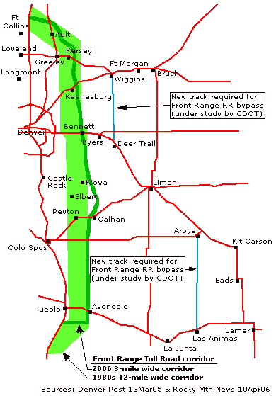
The map at right shows the toll road corridor, both the original
1980s 12-mile wide version and the revised 2006 3-mile wide version.
The map
also shows the two rail lines that would be required as part of a Front
Range railroad bypass currently under study by CDOT. If Prairie Falcon
Parkway Express goes ahead and includes rail lines, the CDOT rail
bypass
project would be scrapped.
Critics of Prairie Falcon Parkway Express have derisively nicknamed it The Superslab.
Sources:
![]()
Continue:
Last updated 9 December 2012