Colorado Highways: Routes 334 to 366
|
Quickjumps Directly to Routes |
||
Colorado Highways: Routes 334 to 366
|
|
|||||||||
![]()
|
Location: Eastern Mountains |
|
|
|
|
|
|
Location: Western Mountains |
|
|
Location: Eastern Mountains History: |
|
|
Location: Western Mountains |
|
|
|
|
|
|
Location: Western Mountains |
|
|
|
|
|
|
Location: Central Western Slope |
|
|
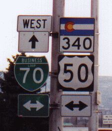
Location: Central Western Slope Counties: Mesa Expressway: From west of the Colorado River over it east into Grand Junction. Milepost Guide:
Annual Average Daily Traffic (2008):
Guide: The I-70 and SH 340 interchange features roundabouts at the southside ramps and south frontage road. The southeast corner of the interchange is also home to a Colorado Welcome Center rest area and Western Slope Vietnam Veterans Memorial. From there SH 340 heads south out of Fruita and across the Colorado River. It then turns southeast, going up the Colorado valley toward Grand Junction. Along the way it parallels the northeast boundary of Colorado National Monument. SH 340 then passes through the suburban development The Redlands on Broadway. Just west of downtown Grand Junction, SH 340 then turns east, goes over the Colorado again, then hits BL I-70/US 50 in central Grand Junction. Photo Gallery:
History: |
||
|
US 340 is a US Highway proposed in 1926 that did not "make the cut". US 340 was the first number proposed for the route from Limon east via Kit Carson and Cheyenne Wells to Kansas. US 40S ended up getting its place when the system was implemented in 1927. |
||
|
Location: Western Mountains |
|
|
Location: Central Western Slope History: |
|
|
Location: Western Slope |
|
|
Location: Northwest Metro Denver History: |
|
|
Location: Western Slope |
|
|
|
|
|
|
Location: Eastern Western Slope |
|
|
Location: Western Slope Counties: Montrose Annual Average Daily Traffic (2008):
Guide: History: |
||
|
|
|
|
|
Location: Western Slope Counties: Delta, Montrose Milepost Guide:
Annual Average Daily Traffic (2008):
Guide: History: |
||
|
Location: Western Slope |
|
|
|
|
|
|
Location: Southern Western Slope |
|
|
Location: Southern Front Range > Arkansas
Valley Counties: Las Animas, Otero
Milepost Guide:
Annual Average Daily Traffic (2008):
Guide: George Gallis in an e-mail mentioned to me one time he drove US 350 from La Junta to Trinidad on a Sunday evening. He saw three cars the whole way, and there was hardly ever a light in any direction. US 350 is one of the very few US highways that are entirely within one state. In fact, AASHTO recommends that US highways confined to one state be decommissioned. Despite being an angled highway, CDOT signs US 350 as east/west. I guess that way it matches the directions of its parent US 50, but it strikes more as a north-south route. If you were in Trinidad would you say you're "going east to La Junta"? Photo Gallery:
History: Also, each end has undergone numerous changes over the years: In Trinidad, from the 1920s US 350 came into town southwest
via Main St. and ended in the center of town at the US 85 intersection
at Commercial St. US 160 appeared in the Trinidad area about 1930, so
US 160 and 350 were comarked between US 85 and the split at Beshoar
Junction. About 1959, the US 85-87 elevated expressway (modern I-25)
appeared through Trinidad, so about that time US 160-350 was extended
southwest down Main St. from Commercial to the new highway. I-25 was
completed along the elevated highway in 1968, so US 350 ended at I-25's
Exit 13B from then until the 1990s. The US 160 Kit Carson Trail bypass
to the north of downtown was built about 1992. We can only assume it
was about the same time that US 350 stopped being marked between
Beshoar Junction and I-25 and US 160 instead became "To 350". In La Junta, US 350 from the 1920s first came into town eastward on 6th St., north on Grant Ave., east on 5th, then north on Santa Fe Ave., ending at US 50 at 3rd St. By 1932, the section of US 350 east of Grant was chopped off and US 350 ended at Grant and US 50 on the west side of town. By 1934 US 350 didn't turn east on 6th, instead it continued northeast along the west side of Potter Park, ending at an intersection with US 50 that today doesn't exist. At
some point, year unknown but probably in the early 1960s, the road
along the west side of
Potter Park was obliterated and US 350 routed west on 5th St and north
on Barnes Ave to US 50. According to right-of-way plans from the '60s
CDOT at that time apparently had an idea to build an interchange at US
50 and Barnes Ave, leading to the alignment of US 350 along Barnes.
However the interchange never came to fruition and it remained an
at-grade intersection. US 350 intersecting US 50 at Barnes lasted until summer 2012, when
CDOT again changed it to go north on Grant Ave to US 50, rather than
Barnes. The city of La Junta accepted the change in order to get truck
traffic off of Barnes Ave, which is residential for the couple blocks
US 350 was routed on it. Suggestions: Related Site: US 350 Endpoints by Dale Sanderson |
||
|
Location: Southwestern Mountains |
|
|
|
|
|
|
Location: Southern Western Slope |
|
|
|
|
|
|
Location: Southern Western Slope |
|
|
|
|
|
|
Location: Southern Western Slope |
|
|
|
|
|
|
Location: Southern Western Slope |
|
|
Location: Northern Mountains History: |
|
|
Location: Southern Western Slope |
|
|
|
|
|
|
Location: Southern Western Slope |
|
|
|
|
|
|
Location: Southern Western Slope Thanks to Thomas Zieber for pointing out this one to me. |
|
|
|
|
|
|
Location: Southern Western Slope |
|
|
|
|
|
|
Location: Southern Western Slope |
|
|
|
Location: Southern Western Slope History: |
|
|
Location: San Luis Valley |
|
|
|
|
|
|
Location: Southern Mountains |
|
|
|
|
|
|
Location: Southern Mountains |
|
|
|
|
|
|
Location: Southern Mountains |
|
|
|
|
|
|
Location: Southern Mountains |
![]()
Continue:
Last updated 9 March 2014


