|
|
Location: Eastern Plains
Alignment: Spur that went west from US 40 at Agate.
Current Elbert CR 162.
Notes: The "40" number is unrelated to US 40 or
current SH 40, instead coming from the clustering system
that was used to assign numbers for 1940s routes.
|
|
|
Location: South Western Slope
Length: 19mi
SW End: New Mexico border just east of the Four
Corners
NE End: Jct US 666 (current US 491) south of
Cortez
History:
Original designation for the road that went from the
Four Corners northeast to US 491. It appears that it was a
totally new road built and opened about 1963. Arizona
designation was AZ 64. It became part of the routing
of US 164 in 1966, and then was decommissioned in the
purge of 1968. US 164 was taken over by US 160 in
1971. Note that SH 41 is nearby (clustering?), and the
Arizona designation is a possible source for the odd US
164 designation. See also my US
164 listing.
|
|

|
Location: Eastern Plains
Counties: Arapahoe, Elbert, Lincoln
Places: Byers, Deer Trail, Agate, Limon
Broken Route: Four separate sections of old US
40-287 along the I-70 southwest frontage road on the Eastern
Plains are still on the state inventory as SH 40. These are:
- Byers Section
- Length*: 1.81mi
NW End: Jct US 36/SH 36 in Byers
SE End: On the I-70 frontage road southeast of
Byers at CR 185 (Calhoun Rd.)
Milepost Guide: Uses US 40 Mileposts 338.57 to
340.38 - Deer Trail Section
- Length*: 5.96mi
NW End: On the I-70 frontage road adjacent to
overpass structures at I-70 MP 323.73 (southeast of
Peoria)
SE End: On the I-70 frontage road adjacent to
overpass structures at I-70 MP 329.74 (CR 42/Wall
Road)
Milepost Guide: Uses US 40 Mileposts 346.29 to
352.25; intersects BS I-70 at MP 350.86 in Deer
Trail - Agate Section
- Length*: 2.80mi
NW End: On the I-70 southwest frontage road
northwest of Agate, where the frontage road separates away from the mainline near I-70 Milepost 338
SE End: Jct BS I-70 in Agate
Milepost Guide: Uses US 40 Mileposts 360.20 to
363.00 - Limon Section
- Length*: 1.49mi
NW End: On the I-70 southwest frontage road
northwest of Limon, where the frontage road separates away from the mainline near I-70 Milepost 358
SE End: Jct US 24-40-287/Spur US 24 west of
Limon
Milepost Guide: Uses US 40 Mileposts 380.69 to
382.18; crosses Elbert-Lincoln County line at MP 381.94
Notes: So numbered because it's old US 40-287
before I-70 was built.
Annual Average Daily Traffic (2008):
- 950 southeast of Byers
- 280 northwest of Deer Trail
- 580 northwest of BS 70, Deer Trail
- 130 southeast of Deer Trail
- 90 northwest of Agate
- 160 northwest of Limon
History and Guide:
It is the I-70 southwest frontage road for its entire
length, and the former route of US 40-287. As described
above, there are four separate sections of old US 40 still
state maintained.
Here is an e-mail from Robert Halonen:
Went on a road trip today in search of
Colorado 40. It is marked from the junction of US-36 and
Colorado 36 in Byers to the I-70 access road in Agate. It
parallels I-70 the entire distance, so it is obviously
old US-40/287. There is also a SH 40 marker in Limon,
just west of the intersection of US 24 and Business 70.
This is another stretch of Old US-40, but the road
quickly deteriorates to gravel NW of Limon and there are
no more SH 40 markers, though mileposts exist to the end
of the road at exit 354.
Part of another e-mail from him:
I don't remember the milepost numbers on SH
40, except that they were somewhat larger than the I-70
mileposts, so I figured they were following US-40's
mileposts. The Limon portion of road had mileposts that
seemed consistent with the rest of SH 40.
The frontage road does not exist between Agate and Exit
354; perhaps they put I-70 over the top of the old
road.
Since SH 40 is following US 40's old alignment, that
explains the mileposts that are present on the frontage road
from Byers all the way to Agate. However, while the
continuous old US 40 mileposts make it look like SH 40 is
continuous, it is divided into four separate sections listed
above. The four different sections listed come from official
2000 CDOT data, so it was correct at least at that time, and
is consistent with what is shown on the 1999 CDOT map. Back
in the 1970s, SH 40 existed in basically the same place
according to the 1971 and 1976 route logs:
- From Jct SH/US 36 in Byers to Jct I-70 southeast of
Byers;
- From Jct I-70 northwest of Deer Trail to Jct I-70
southeast of Deer Trail;
- From the I-70 frontage road northwest of Agate
southeast for *2.100mi to Jct BS I-70 in Agate; and
- From Jct I-70 southeast of River Bend southeast to
Jct US 24 west of Limon.
That last section northwest of Limon would have served as
Temp I-70 until I-70 was completed in that area in 1979.
This explains the Limon section that still exists.
Photo Gallery:
- SH
36/US 36 Markers, Byers. Unusual marker assembly
on westbound SH 40 in Byers. February 2003
- End
Pavement Near Limon. Northwestbound on the Limon
section of SH 40, here at the end of pavement northwest
of the west Limon intersection. This point also appears
to correspond to the end of state maintenance. Photo by
Dale Sanderson. (December 2003)
- SH
40/To West I-70. Picture on westbound SH 40 just
west of the US 24-40-287/BL 70/Spur 24 intersection
northwest of Limon. Note the gate that can be closed in
event of severe winter weather. According to Dale
Sanderson as of December 2003 these signs no longer
exist. Photo courtesy Robert Halonen.
|
|
|
|
|

|
Location: North Western Slope > Central
Mountains > Metro Denver > Eastern Plains
Length*: 403.84mi signed; 486.92mi implied
W End: Utah
border west of Dinosaur
E End: Kansas
border east of Arapahoe (link to Richie Kennedy's site)
Nationally: W End: Jct I-80 near Park City, Utah; E
End: Atlantic City, New Jersey (2054mi)
Counties: Moffat, Routt, Jackson, Grand, Clear
Creek, Jefferson, Denver, Adams, Arapahoe, Lincoln,
Cheyenne
Places: Dinosaur, Maybell, Craig, Hayden, Steamboat
Springs, Rabbit Ears Pass, Muddy Creek Pass, Kremmling, Hot
Sulphur Springs, Granby, Fraser, Winter Park, Berthoud Pass,
Empire, Golden, Lakewood, Denver, Aurora, Limon, Hugo, Kit
Carson, Cheyenne Wells
See the separate US 40
page for the remainder of the information.
|
|

|
Location: Eastern Plains
Length: 87mi
W End: Limon
E End: Kansas border east of Burlington
Alignment: Current US 24/I-70 (Limon, Seibert, Vona,
Burlington)
Nationally: E End: Jct US 40 at Manhattan, Kansas
History:
US 40 originally, dating from 1927, had a north/south
split which had its eastern end at Manhattan, Kansas. US
40N went west from Manhattan along current US 24/I-70,
through Burlington and Stratton, ending at Limon. It was
renumbered to US 24 in 1936. See the US 40 history for the
reason for the north/south split.
|
|
|
|
|

|
Location: Western Slope > Central Mountains
> South Front Range > Eastern Plains
Length: 482mi
W End: Jct US 50 at Grand Junction
E End: Kansas border east of Cheyenne Wells
Alignment: Current I-70/US 6/US 24/US 40 (Grand Junction,
Rifle, Glenwood Springs, Leadville, Buena Vista, Woodland
Park, Colorado Springs, Limon, Kit Carson, Cheyenne
Wells)
Nationally: E End: Jct US 40 at Manhattan, Kansas
History:
The southern branch of the US 40N/S split was
much longer. From Manhattan, Kansas, it followed current US
40 to Limon, where it continued west via current US 24
and through Colorado Springs, Buena Vista, Leadville, Eagle and Glenwood Springs,
ending at US 50 in Grand Junction.
As pointed out to me by Paul Bardell, one major alignment
difference in the early days of the route was DeBeque Canyon. The
canyon, between Palisade and DeBeque and called Hogback Canyon back
then, was not the original routing for US 40S in the 1920s. No road was through the canyon, so US 40S
from Palisade went east up current SH 65 to near the current SH 330
intersection, then north to DeBeque on today's DeBeque Cutoff Road and continuing on toward Parachute.
A road through DeBeque Canyon was built about 1930 and US 40S
run along it. A monument to that road opening, placed by the Grand
Junction Elks, is today near the truck stop at the Island Acres
interchange (I-70 Exit 47). See photo gallery below.
The section of US 40S between
Manhattan and Limon became US 40 while the section from
Limon to Grand Junction became US 24 in 1936. The west end
of US 40S never touched US 40. The fact that
40S became 24 explains the weird overlap that 24
had with US 6 to Grand Junction, since US 6 was extended
westward through there in 1937. See the US 40 history for
the reason for the north/south split.
When the US Highway system was first proposed in 1926, US 40S from Limon to Grand Junction was slated to be US 46.
But due to the 40 N/S controversy in Kansas 46 never appeared when the
system was implemented in 1927 and we got the N/S split instead.
Photo Gallery:
- Colorado River Highway Monument: Overview • Plaque. Monument placed by the Grand Junction Elks commemorating the opening of the brand-new road through DeBeque Canyon which US 40S
was routed on in 1930. Monument is on I-70's east side at the Island
Acres interchange (Exit 47). Photos by Brett Blaney. (2013)
- Old Road Alignment in DeBeque Canyon. Remnant of what may have been US 40S (and later US 6-24) in DeBeque Canyon, before I-70 was built through the canyon. Photo by Brett Blaney. (2013)
|
|
|
Location: Eastern Plains
Alignment: Spur north from US 24 at Bovina, then from
Bovina southwest to US 40 at Hugo
|
|

|
Location: South Western Slope
Length*: 9.50mi
SE End: Jct US 160 northeast of the Four Corners
NW End: Utah border southeast of Aneth, connecting to
UT 162
Counties: Montezuma
Annual Average Daily Traffic (2008): 1000
 Scenic & Historic Byways: Trail of the Ancients Scenic & Historic Byways: Trail of the Ancients 
Photo Gallery:
- Utah Border.
Looking on SH 41 into Colorado at the Utah border, with the area's
rocky landscape as a backdrop. Photo by David Herrera. (October 2011)
History:
Came into the state system about 1965. Alignment was previously not a
state highway. The highway that SH 41 connects to in Utah was at first
numbered UT 262 but changed to UT 162 in 2004. |
|
|
Location: Eastern Plains
Alignment: Spur west from SH 109 north of
Genoa
|
|

|
Location: North Metro Denver
Length*: 4.87mi
NW End: Jct SH 7 west of Lafayette
SE End: Jct US 287 south of Lafayette
Counties: Boulder
Places: Louisville, Lafayette
Roadway Names:
- 95th Street from SH 7 to Baseline Rd
- Courtesy Road from Baseline Rd to Empire Rd
- East-west section is Empire Road
Annual Average Daily Traffic (2008):
- 14,900 at SH 7
- 18,200 south of Baseline Rd., Louisville
- 7900 at US 287
Guide:
Ties downtown Louisville to SH 7 and US 287. That "s" in
Louisville is not silent. It starts at a signal at SH 7
& 95th Street, heads due south, and skirts the east side
of downtown. At Pine Street is where one can turn west across some BNSF tracks into
downtown Louisville. SH 42 then makes a 90� turn to
the east, and heads along Empire Road to a signal at the US
287 expressway.
History:
Alignment became a state highway originally in the 1920s as
SH 168. The route existed as that through about 1950
when it was turned back. The alignment was then brought back
into the state system by 1961, but at first maps didn't show
what number it was. The 1965 state map is the first one to
definitively show it as SH 42.
|
|
|
Location: Eastern Plains
Alignment: Spur south from US 24 at Bethune
|
|
|
|
|
|
Location: Eastern Plains
Alignment: Spur northwest from SH 51 (current
US 385) north of Burlington
|
|

|
Location: Northeast Metro Denver
Length*: 4.95mi
E End: Jct SH 2 in Commerce City
W End: Intersection of 104th Ave. and Colorado Blvd.
in Thornton
Counties: Adams
Places: Thornton, Commerce City
NHS: Entire length
Roadway Names: 104th Avenue
Milepost Guide:
- 0.00: SH 2 (begin SH 44 in Adams County)
- 1.80: US 85
- 4.95: Colorado Blvd. (end SH 44)
Annual Average Daily Traffic (2008):
- 12,800 at SH 2
- 14,200 west of US 85
- 18,300 west of McKay Rd.
- 18,400 at Colorado Blvd.
Guide:
Used as a way across the northern metro, and is one of the
ways to get from I-25 over to Denver International Airport.
It does not have an interchange with I-76, instead only an
overpass. It is one of the few streets/highways that has a
bridge over the South Platte between Commerce City and
Brighton.
History:
Routing unchanged, but originally designated SH 24
(via the clustering system) when the alignment was brought
into the state system about 1954. Designation changed to SH
44 in the purge of 1968 to avoid duplication with US 24.
|
|
|
Location: Eastern Plains
Alignment: Spur northwest from SH 51 (current
US 385) at Cheyenne Wells
|
|

|
Location: West Pueblo
Length*: 8.73mi
S End: Jct I-25 Exit 94 south of Pueblo
N End: Jct US 50 northwest of Pueblo
Counties: Pueblo
NHS: Entire length
Expressway: Four-lane divided north of SH 96/Thatcher Ave.
Roadway Names: Pueblo Boulevard
Notes: SH 45 is planned to eventually continue
northeast from US 50, ending at I-25 around Milepost 103.
Milepost Guide:
- 0.00: I-25 Exit 94 interchange south of Pueblo
(begin SH 45 in Pueblo County)
- 3.14: SH 78/Northern Ave.
- 4.73: SH 96/Thatcher Ave.
- 8.73: US 50 (end SH 45)
- 11.93: Projected end at I-25
Annual Average Daily Traffic (2008):
- 17,200 at I-25
- 11,700 west of Hollywood Dr.
- 30,300 north of Lehigh St
- 22,800 north of SH 96/Thatcher Ave.
- 21,900 at US 50
Guide:
SH 45 forms a pseudo-beltway around the western side of Pueblo. From
I-25 Exit 94, SH 45 heads west as a undivided multi-lane city street
through Pueblo's southern reaches. After turning north, it goes through
a commercial strip, intersecting SH 78 at Northern Ave. and SH 96 at
Thatcher Ave. along the way. North of Thatcher SH 45 becomes a
full-blown expressway, four-lane divided with a 55mph speed limit.
SH 45 continues north,
crossing the Arkansas River, then intersects US 50. US 50 is divided
with the two directions far apart, so SH 45
uses two sets of signals. US 50 has its two direction far apart at SH
45 because it uses what would be the ramps if a diamond interchange is
ever put in at the location.
Photo Gallery:
- Near Northern Avenue. SH 45 (Pueblo Boulevard) northbound north of SH 78/Northern Avenue. Here SH 45 is low-speed commercial strip. (May 2004)
History:
First started being built in the 1960s, with the first
section from I-25 northwest to SH 96 opening by 1966. By
1973, it was extended north to 11th St., and was completed
north to US 50 by 1975.
|
|
|
Location: Eastern Plains
Alignment: Link from US 40 at Hugo due west to SH 71
|
|

|
Location: Central Mountains
Length*: 6.61mi
W End: Jct SH 119 north of Black Hawk
E End: Becomes Jefferson CR 70 at the
Gilpin/Jefferson County Line
Counties: Gilpin
Places: Golden Gate Canyon State Park
Roadway Names: Golden Gate Canyon Road
Annual Average Daily Traffic (2008):
- 1800 at SH 119
- 1400 in Golden Gate Canyon State Park
- 1600 at east end
History:
Routing is an original 1920s state highway, but started off
designated as SH 58. That highway went from SH 119
down Golden Gate Canyon to Golden, and then east all the way
to Denver. This is where the current SH 58's number is
derived from. SH 58 was scaled back to the Golden-Denver
link it is by 1954, leaving the roadway in Golden Gate
Canyon as a county road.
The roadway was then brought back into the state system
and designated SH 46 in 1971, but at first it was only
*3.75mi long, having its eastern end at the entrance to
Golden Gate Canyon State Park, and was all gravel. By 1974
that section was paved, and then it was extended east to the
county line by 1985. It still had one gravel segment which
was paved by 1986.
|
|

|
US 46 appears to be a US route which didn't "make
the cut" when the system first came out. As first proposed
in 1926, US 46 would have had the current route of US
24 and I-70, starting at Limon, through Colorado Springs,
Buena Vista, Leadville, Eagle and Glenwood Springs, ending at Grand Junction.
US 40S got its place instead was the US system was
implemented in 1927.
|
|
|
Location: Eastern Plains
Alignment: Spur northwest from SH 45 northwest
of Cheyenne Wells
|
|

|
Location: Northeast Pueblo
Length*: 4.63mi
NW End: Jct I-25/US 50 Exit 101 in north Pueblo
SE End: Jct US 50/SH 96 interchange east of Pueblo
Counties: Pueblo
NHS: Entire length
Freeway: East of Dillon Dr. to east of Troy Ave.
Roadway Names: University Boulevard
Memorial Designations: C�sar Ch�vez Memorial Parkway
Annual Average Daily Traffic (2008):
- 31,500 at I-25/US 50
- 35,900 east of Pueblo Mall
- 18,400 east of Jerry Murphy Rd.
- 8400 southeast of Troy Ave.
- 10,100 at US 50/SH 96
Guide:
SH
47 serves as a bypass for traffic going around Pueblo's northeast side
as well as the main access to Colorado State University-Pueblo. It is
signed as a US 50 bypass, with signs on EB US 50 west of I-25 saying to
continue straight ahead on SH 47 to get to US 50 and La Junta.
The interchange at SH 47's northwest end is a SPUI at I-25/US
50. Coming east from the SPUI, SH 47 is a divided road with a 40mph
speed limit, then has a signal at an intersection with Dillon Drive
where one accesses Pueblo Mall. East of Dillon SH 47
becomes a full-blown freeway with a 55mph speed limit. First there's an
interchange with Jerry Murphy Rd., then partial interchanges at Walking
Stick Blvd. and Bonforte Blvd., accessing CSU-P. Then there's a full
interchange at Troy Ave., also accessing CSU-P.
East of Troy Ave. SH 47 reverts back to a two-lane road,
effectively ending the freeway, but it's still about another mile until
the next intersection, Baculite Mesa Road. Curving south, SH 47
intersects 13th St., then hits the diamond interchange at US 50/SH 96.
The interchange is kind of tilted diagonally along US 50 with that as
the through route, so if you go south on SH 47 over US 50, you end up
westbound on SH 96/4th Street.
Photo Gallery:
- Bonforte Overpass Looking West. The view looking west along SH 47 from the Bonforte Blvd. overpass, one of the highest vantage points in the area. (May 2004)
- Pete Jim�nez Parkway Left Turn. This leads over to Pueblo Airport, and features the left lane becoming a left-turn-only lane at the intersection. (August 2010)
- Juntion 50 & 96, End 47. Sign assembly approaching SH 47's south end at the US 50/SH 96 interchange. (August 2010)
History:
Started being built in the 1970s from northwest to
southeast. First section from I-25 southeast to Bonforte
opened by 1971, and was completed to US 50/SH 96 by 1979. A
new interchange at 50/96/47 was put in by 1982.
Suggestions:
As part of the US 50 Southeast Colorado Corridor Study, it's
possible SH 47 will be tagged as the main route coming east from I-25
rather than existing US 50. If that happens it would make sense to
shift US 50 to SH 47, extend the freeway southeast to the existing
50/47/96 interchange, and reconstruct that interchange to make 50
<-> existing 47 the through route through the interchange.
|
|
|
Location: Eastern Plains
Alignment: Spur west from SH 109 south of Hugo
|
|
|
|
|
|
Location: Eastern Plains
Alignment: Spur north from US 40 at Arapahoe
|
|
|
Location: Northwest Metro Denver
SE End: I-25 & Boulder Turnpike/US 36
NW End: Baseline Road, Boulder
Alignment: Denver-Boulder Turnpike through
Westminster and Broomfield
Roadway Names: Denver-Boulder Turnpike
History:
This SH 49 was created to serve as the carrier SH
route number along the Denver-Boulder Turnpike when it
became free in 1967 and US 36 was run up it. SH 49
was then decommissioned with all of the other carrier routes
in the purge of 1968. My opinion is that they could have
just used SH 382 as the carrier route along the
turnpike since that was already the SH number, since 1954,
for the connection from I-25 to the start of the turnpike at
Federal.
|
|
|
Location: South Front Range > Eastern
Plains
W End: Jct US 85-87 at Monument
E End: Up to 1954: Jct US 24 at Peyton; 1955 to 1964:
Spur east of SH 83 east of Monument; 1965-1968: Jct SH 83
east of Monument
History:
SH 50 is an original 1920s state highway that started at
current I-25/US 85-87 at Monument, then went east via
current SH 105, then east to Eastonville via Hodgen Road,
then southeast ending at US 24 at Peyton. By 1955, it had
been scaled back east of SH 83, ending as a spur 8mi east of
SH 83 probably at Vollmer Road. By 1965 the east end was
trimmed back even more to end at SH 83. All this time SH
50 had not been paved, but finally was by 1966. It was
renumbered as an extension of SH 105 in the purge of 1968 to
avoid duplication with US 50.
|
|

|
Location: Central Western Slope > Central
Mountains > Southern Front Range > Arkansas Valley
Length*: 441.48mi signed; 467.58mi implied
W End: Utah
border on unmarked overlap with I-70
E End: Kansas
border east of Holly (link to Richie Kennedy's site)
Nationally: W End: Jct I-80 in Sacramento, Califonia;
E End: Ocean City, Maryland (3011mi)
Counties: Mesa, Delta, Montrose, Gunnison,
Saguache, Chaffee, Fremont, Pueblo, Otero, Bent, Prowers
Places: Grand Junction, Delta, Olathe, Montrose,
Gunnison, Monarch Pass, Poncha Springs, Salida, Howard, Ca�on City, Penrose, Pueblo West, Pueblo, Fowler,
Manzanola, Rocky Ford, Swink, La Junta, Las Animas, Lamar,
Granada, Holly
See the separate US 50
page for the remainder of the information.Related Site: Route50.com,
from Wulf Berg of Virginia.
|
|
|
Location: Arkansas Valley > Eastern Plains
S End: 1920s-1953: Kansas border (connection to
KS
51); 1953-1968: Granada
N End: 1920s-1953: Nebraska border north of
Julesburg; 1953-1968: Julesburg
Places: Midway, Stonington, Walsh, Granada, Cheyenne
Wells, Burlington, Holyoke, Julesburg
History:
Original 1920s state highway. Starting where KS 51 now
ends at the border, it went west to Midway, north to
Stonington, northwest to Walsh, northwest to Two Buttes, and
north to Granada. From there north, it took current US 385
to Julesburg. It then took current SH 11 (maybe) north to
Nebraska. Also, south of Wray the road originally was
shifted west of where it is now to go through Vernon and
Idalia.
By 1954, all of SH 51 south of Granada had been turned
back, leaving KS 51 dangling at the border, and the section
north of Julesburg had been turned back. Also by 1954 it had
begun being paved in scattered patches around towns. By 1957
it was paved from Cheyenne Wells to Julesburg, and was
entirely paved by 1964.
All of SH 51 became part of US 385, and its de
facto carrier route, in 1959. SH 51 was then
decommissioned with all the other carrier routes in the
purge of 1968.
|
|

|
Location: North Metro Denver
Length*: 5.15mi
S End: Jct I-76 Exit 17 southwest of Barr Lake
N End: Jct SH 7 at 4th Ave. and Bridge St. in
Brighton
History:
Designation for what is now SH 2 along Sable Blvd. from
Brighton south to I-76. SH 51 started at 4th Ave. and
Bridge St. in Brighton, and went due south on 4th, becoming
Sable Blvd. when it got out of the city limits, and
continued south to I-76 Exit 17, ending at the trumpet
interchange.
SH 51's alignment originally became a state
highway as part of SH 70 when SH 70 was
extended northward in 1939. It was then changed to SH
51 in the purge of 1968 to avoid duplication with I-70.
SH 51 was then renumbered as an extension of SH 2
(which previously had its north end at I-76 Exit 16)
sometime between March and July 1998. The second renumbering
was done in preparation for the then-upcoming interchange
overhaul of the I-76/Sable/120th Ave. area that started in
August 1998.
|
|

|
Location: North Front Range > North Eastern
Plains
Length*: 97.67mi signed; 111.57mi implied
W End: Jct SH 119 southwest of Niwot
E End: Jct SH 14 east of Raymer
Counties: Boulder, Weld, Morgan
Places: Niwot, Dacono, Fort Lupton, Hudson, Prospect
Valley, Wiggins, Fort Morgan
Broken Route: SH 52 is broken between Wiggins and
Fort Morgan. There is a gap of 14.9mi along I-76 and US 34.
Roadway Names: In Boulder County, Mineral Road
Scenic & Historic Byways: Pawnee Pioneer Trails (Fort Morgan to SH 14)
|
Milepost Guide:
- 0.00: SH 119 southwest of Niwot (begin SH
52 in Boulder County)
- 4.67: US 287 south of Longmont
- 7.20: Enter Weld County
- 11.16: I-25 Exit 235 interchange west of
Dacono
- 19.96: US 85 interchange, Fort Lupton
- 20.45: BR US 85, Fort Lupton
- 29.27: I-76 Exit 31 interchange, Hudson
- 41.93: SH 79, Prospect Valley
- 55.90: Enter Morgan County
- 72.58: SH 39/US 6, Wiggins (end SH 52)
- 86.48: US 34, Fort Morgan (begin SH 52 in Morgan County)
- 86.98: SH 144/Riverview Dr.
- 87.16: I-76 Exit 80 interchange
- 105.55: Enter Weld County
- 111.57: SH 14 (end SH 52)
|
Annual Average Daily Traffic (2008):
- 9200 at SH 119
- 16,800 east of US 287
- 17,600 east of I-25
- 13,500 east of Colorado Ave., Dacono
- 9200 west of US 85, Fort Lupton
- 14,600 east of US 85, Fort Lupton
- 4900 east of CR 37
- 5900 east of I-76, Hudson
- 1600 east of CR 59
- 1000 east of SH 79, Prospect Valley
- 340 east of CR 3
- 930 north of CR P
- 2600 at SH 39/US 6, Wiggins
- 8400 north of US 34, Fort Morgan
- 9400 north of SH 144
- 1700 north of CR T.5
- 450 at SH 14
|
Guide:
SH 52 kinda reminds me of those "meandering" highways that
Wisconsin has; they always seem to be searching for where
they want to go. SH 52's western end at SH 119 is in an
interesting spot: Going west from that intersection is the
access road for a huge IBM plant. As in illustration of the
kind of traffic in the Northern Front Range, let me point
out that the SH 52/US 287 intersection, basically out in the
middle of nowhere, has a signal light. There are also four
sets of signals at the I-25 interchange, at each of the two
ramps and the two frontage roads.
Continuing east, SH 52 goes east through Dacono, then on
to Fort Lupton. It goes east through town as 1st St., and
includes an interchange with the US 85 expressway on the
west side of town. That interchange is also the southern end
of the Fort Lupton BR US 85, which goes east along SH 52 to
Denver Ave., where BR US 85 turns north to hook back up with
US 85 on the north side of town.
From Fort Lupton, SH 52 heads east to Hudson, where it
goes through I-76 Exit 31. SH 52 continues east through the
crossroads town (at SH 79) of Prospect Valley, and at Morgan
CR 5, SH 52 abruptly turns north. It's then a straight shot
toward Wiggins, where SH 52 disappears at I-76 Exit 66, also
meeting US 6 and SH 39 in the same area.
SH
52 materializes again in downtown Fort Morgan, at the intersection of
Main St. and Platte Ave. From US 34, SH 52 heads north on Main, through
I-76 Exit 80. Just north of I-76 SH 52 crosses the South Platte River
adjacent to the historic Rainbow Arch Bridge (see photos below). SH 52 then
has an usual about 3/4 mile four-lane divided section north of the
river, then reverts back to two lanes. it then goes north to SH 14 east
of Raymer.
Photo Gallery:
- Fort Morgan Rainbow Arch Bridge Straight On • Side • Replacement Structure • Plaque:
The Rainbow Arch Bridge, on SH 52 just north of I-76 over the South
Platte River, was built in 1922. The concrete arches, rather than being
totally above or below the deck, are partly on either side. The
replacement structure was built in 1963 right next to it. I paced off
the deck at only 20' wide, no wonder it had to be replaced. The bridge
now serves as part of a walking path that ties to an adjacent city
park. (April 2004)
History:
SH 52 is an original 1920s state highway, except its western
end was at US 87 (current US 287). Also, it
originally was shifted, and came north into Wiggins one mile
further west along Morgan CR 1. By 1938 it was paved from
SH 185 (current I-25) east to Hudson, and by 1950 the
paving was extended from SH 185 west to US 287. By
1954 more paving was done east to Prospect Valley, from the
90� curve north to Wiggins, and for 12mi north of US
34. Paving was completed from US 34 to SH 14 by 1956, and SH
52 was paved in its entirety by 1964. It was extended from
US 287 west to SH 119 by 1965.
Improvements to the I-25 interchange were completed in
Fall 2001. SH 52 had previously been a simple diamond with a
two-lane overpass, but was upgraded to four lanes with turn
lanes, and signals at the ramps and frontage roads. The
improvements were needed, because traffic at the interchange
was high, and at some times of the day (such as when a shift
at the IBM plant let out) turning left onto SH 52 at the
interchange was near impossible.
|
|
|
Location: Eastern Plains
S End: Jct US 24 east of Burlington
N End: Jct SH 51 south of Wray
History:
Original 1920s state highway. It started at SH 51
(current US 385) south of Wray, and then went southeast and
hugged the border, ending at US 24. On the 1937 map, it's
labeled the Beecher Island Highway, and went past the
Beecher Island Battle Ground. Turned back about 1953.
|
|

|
Location: North Metro Denver
Length*: 1.66mi
S End: Jct I-25 and 58th Ave. at Exit 215
N End: Jct SH 224 at Broadway and 70th Ave.
Counties: Adams
Roadway Names: North Broadway
Annual Average Daily Traffic (2008):
- 18,100 at I-25
- 11,900 at SH 224/70th Ave.
Guide:
This highway is at the top of the list as totally
unexplainable highway in the Metro. After starting at its
north end, it heads due south on Broadway for twelve blocks,
and then turns east on 58th for one short block to I-25. SH
53 is not marked on I-25, nor are there "END 53" signs at SH
224.
History:
Brought into the state system in 1971.
|
|
|
Location: North Eastern Plains
W End: Brush
E End: Nebraska border east of Wray
Alignment: Current US 34 (Brush, Akron, Yuma, Wray)
History:
SH 54 is an original 1920s state highway that was
used for the highway from Brush to Wray into Nebraska. It
was entirely paved by 1936, and in 1939 US 34 commandeered
the entire route, and SH 54 became the de facto
carrier route for US 34. It was decommissioned, along with
other carrier routes, in the purge of 1968.
|
|
|
Location: South Front Range
W End: Jct US 350 at Beshoar Jct.
E End: 1920s-1949: New Mexico border at Branson;
1950: Jct SH 206 east of Trinidad
Places: Beshoar Junction, Trinchera, Branson
History:
SH 55 is an original 1920s highway that went from
US 350 at Beshoar Junction, northeast of Trinidad, southwest
to Trinchera then to Branson, and south into New Mexico. It
was the original route for US 160 between Trinidad and
Branson when US 160 was extended west from Kansas 1932. In
1950, US 160 was shifted to a new alignment along SH
100 to the north, so SH 55 was deemed not
necessary anymore, and had its east end trimmed back to the
intersection with SH 206 east of Trinidad. It was
then turned back entirely the next year.
|
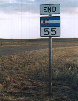
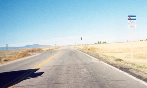
|

|
Location: North Eastern Plains
Length*: 5.65mi
N End: Jct US 138 at 1st St. and 2nd Ave. in
Crook
S End: Becomes Logan CR 81 south of Crook
Counties: Logan
Milepost Guide:
- 0.00: US 138, Crook (begin SH 55 in Logan County)
- 2.41: I-76 Exit 149 interchange south of
Crook
- 5.65: End SH 55
Annual Average Daily Traffic (2008):
- 330 at US 138
- 920 south of I-76 (slightly misleading, number is probably due to the gas station just south of the interchange)
Guide:
SH 55 starts
at US 138 in Crook, goes south across the South Platte River and
through I-76 Exit 149. SH 55 then climbs up the hill out of the river
valley and becomes a county road 3 miles south of I-76. There's no
intersection at SH 55's south end, it's simply a sign and change in
pavement.
The SH 55 exit
on I-76 and US 138 intersection in Crook are given the destination of Fleming, as SH
55 feeds into the county road that heads south to it.
Photo Gallery:
- US 138 End. Signs at the right turn for SH 55 to US 138 in Crook. May 2007
- I-76 Overpass.
Southbound on SH 55 approaching the I-76 interchange and overpass. In
the distance are the hills SH 55 climbs as it exits the South Platte
valley. May 2007
- Northbound SH 55. A couple miles south of I-76 on northbound SH 55 as it descends down the rollings hills into the South Platte valley. May 2007
- End SH 55.
SH 55's south end south of I-76. There's no intersection, the state
highway simply ends and becomes a county road. The road continues off
in the distance toward Fleming. May 2007
- Begin SH 55. SH 55's south beginning point, with it curving off for its drop down into the South Platte valley. May 2007
History:
Routing became a state highway in 1939, and was designated
as part of SH 25 (via the clustering system). SH
25 was a much larger highway, starting at the Nebraska
border north of Crook, and going south all the way to US 34
at Hyde. By 1954, though, chunks of SH 25 were turned
back so that it existed only as SH 55 does now. It's been
that way since then, with a renumbering to SH 55 to avoid
duplication with I-25 in the purge of 1968.
|
|
|
|
|

|
Location: North Front Range
Length*: 6.53mi
W End: Jct US 287 west of
Berthoud
E End: I-25 Exit 250 east frontage road east of Berthoud
Counties: Larimer, Weld
Places: Berthoud
Memorial Designations: Staff Sergeant
Justin Bauer Memorial Highway. Bauer was raised in Berthoud and was a
Bronze Star recipient. He died in an IED attack in Baghdad in January
2009.
Milepost Guide:
- 3.00: US 287 west of Berthoud (begin SH 56 in Larimer County)
- 5.52: Enter Weld County
- 9.46: I-25 Exit 250 interchange
- 9.53: I-25 east frontage road (end SH 56)
Annual Average Daily Traffic (2008):
- 14,300 at US 287
- 6700 east of 2nd St
- 4900 at I-25
Guide:
Starting
off at US 287, SH 56 heads due east, going through
downtown Berthoud on Mountain Ave. East of town SH 56 continues due east to
I-25. The former intersection of SH 56 and US 287 west of Berthoud (at Meadowlark Drive) is historically known as Berts Corner.
Photo Gallery:
- Old SH 56 West
End. A blurry picture of westbound SH 56
approaching its former end at the CR 23-8E intersection. On the right you
can see a 56 shield with the "END" plaque below it rather
than above. (October 1999)
- Westbound at US 287. Signs on westbound SH 56 at the US 287 bypass west of Bethoud. Photo by Dale Sanderson. (March 2007)
- Heading West from I-25. The view at the beginning of SH 56 westbound from I-25. Photo by Dale Sanderson. (March 2007)
History:
Original 1920s state highway. It started off at US 87
(currently US 287) west of Berthoud at Berts Corner, then
headed northwest, ending at US 34. By 1939 it was extended
east to SH 185 (current I-25). By 1950 the northwest
end was trimmed back so that it reached only halfway from
Berts Corner to US 34, and was paved from Berthoud to SH
185. By 1954 sections at each end were turned back so
that SH 56 went only from Berts Corner west to the CR 23/8E intersection. But
then the next year it was again extended east to SH
185, and was entirely paved.
The US 287 Berthoud bypass was completed in August 2006.
Previous to that US 287 and SH 56 were comarked along Mountain Ave
through town between the two US 287 curves. The west curve was at Berts
Corner, the east at 1st Ave. From August 2006 to spring 2007, SH 56
went from CR 23/8E east through Berthoud with no overlapping US 287 to
I-25. The section of SH 56 between CR 23/8E and US 287 was turned back
in spring 2007 as part of the North Front Range route swap.
|
|
|
|
|

|
Location: Stratton (Eastern Plains)
Length*: 0.53mi
S End: Jct I-70 Exit 419 at Stratton
N End: Jct US 24 at Colorado Ave. and 4th St. in
Stratton
Counties: Kit Carson
Annual Average Daily Traffic (2008): 1600
Notes: SH 57 is a totally unmarked route, no signs for it exist anywhere.
History:
This short section is all that remains today of a once long
highway. SH 57 is an original 1920s highway (numbered via
the geographical system) that started at US 36 north of
Kirk, and headed south, ending at US 24 at Stratton. By 1939
a spur had been added that took SH 57 another 8mi south of
Stratton. However, most of SH 57 had been turned back by
1954 so all that was left was a spur which went north from
US 24 for 9 miles. That section was paved by 1956. Adding
the link between US 24 and I-70 was done sometime about
1966, and turning back the section north of US 24 was done
in 1992.
Suggestions: Get rid of it or mark it as an I-70
Business Spur.
|
|
|
|
|

|
Location: West Metro Denver
Length*: 5.63mi
W End: Jct US 6/SH 93 in Golden
E End: Jct I-70 Exit 265 in Wheat Ridge
Counties: Jefferson
Places: Golden, Wheat Ridge
Freeway: From east of US 6/SH 93 to its east end
(exit list). West end at
US 6/SH 93 is a signal light.
Annual Average Daily Traffic (2008):
- 11,900 at US 6/SH 93
- 15,800 east of Washington Ave.
- 25,400 at I-70
Guide:
SH 58 is the second major link (the other being 6th
Ave.) between Golden and Denver. While most maps show its
entire length as freeway, the western end at US 6/SH 93 is
just a standard four-way intersection with a signal light.
The portion from there through Golden to the east side of
town has as 50mph speed limit, then goes up to 65mph from
there to I-70. SH 58 has exits at Washington Ave. in central
Golden, an exit westbound only to Boyd St. on the east side
of town, McIntyre St. on the east side of the Coors Brewery,
and then I-70. SH 58 closely parallels 44th Avenue for much of its length.
Photo Gallery:
- Washington Avenue Construction: View down EB SH 58 • View south on Washington • West half of bridge construction.
These are three shots taken while the bridge that takes Washington Ave
over SH 58 was being replaced. A new pedestrian bridge was in place
east of the bridge, while traffic was on one half while the western
half was under construction. (January 2009)
- Eastbound Washington Onramp.
A rare, for Colorado, "freeway entrance" sign at the onramp to EB SH 58
form Washington Ave. When this picture was taken, 7th Street had been
commandeered as a construction staging area. (January 2009)
- Route Marker Snafu.
This marker assembly on northbound Washington incorrectly uses a US
marker for SH 93. US 93 does exist in the direction indicated, but
Nevada is a long ways away. Photo by Robert Halonen. (June 2010)
- I-70 Flyover.
A picture taken while on the flyover from eastbound I-70 to SH 58. The
flyover is the top, third level of the interchange. (January 2009)
History:
SH 58 is an original 1920s state highway that started off at
SH 119 north of Blackhawk, and then headed southeast via
current SH 46 and Golden Gate Canyon Road down to Golden.
From Golden, it went east along West 44th Ave., ending at
Federal Blvd. northwest of downtown Denver. By 1939, a short
loop of SH 58 had been added that went from SH 119 at
Blackhawk north to the original 58-119 intersection. By
1954, all of SH 58 west of Golden had been turned back,
leaving only the section along 44th Ave. from Golden to
Federal Blvd. By 1963 the east end was trimmed back to
Sheridan Blvd., and trimmed back even further to Wadsworth
Blvd. by 1967.
In
1970 the exact routing of SH 58 was from US 6, along 10th St. through
Golden, then northeast along 44th Ave. to Ward Rd. By 1971 an
expressway had been built for it from US 6 to west of McIntyre St., and
was extended to I-70 by 1973. It was upgraded to freeway by 1974. The
interchange at I-70 was only a partial interchange, with movements only
from WB 70-WB 58 and EB 58-EB 70 provided.
A partial interchange was put in at US 6 in 1963, but was taken
out with the realignment of SH 93's south end in 1992. In 2007 CDOT
began constructing the missing movements at the I-70 interchange. The
EB 58 to WB 70 ramp opened in early 2008, and the EB 70 to WB 58 flyover opened December 2008.
|
|
|
|
|

|
Location: Eastern Plains
Length*: 166.01mi signed; 173.34mi implied
S End: Jct US 40-287 at Kit Carson
N End: Jct US 138 in Sedgwick
Counties: Cheyenne, Kit Carson, Washington, Yuma,
Phillips, Sedgwick
Places: Kit Carson, Seibert, Cope, Yuma, Haxtun,
Sedgwick
Broken Route: Despite being relatively short, the SH 59
overlap with US 36 is not marked. Each intersection treats SH 59 as
separate segments.
|
Milepost Guide:
- 0.00: US 40-287 (begin SH 59 in Cheyenne County)
- 19.03: Enter Kit Carson County
- 41.02: I-70 Exit 405 interchange, Seibert
- 41.47: US 24/2nd St., Seibert
- 60.45: Enter Washington County
- 67.14: West jct US 36, Cope (end SH 59)
- 74.47: East jct US 36 (begin SH 59 in Yuma County)
- 106.29: US 34/8th Ave., Yuma
- 133.64: Enter Phillips County
- 147.21: US 6/1st St., Haxtun
- 158.66: Enter Sedgwick County
- 171.07: I-76 Exit 165 interchange south of
Sedgwick
- 173.34: US 138, Sedgwick (end SH 59)
|
Annual Average Daily Traffic (2008):
- 470 at US 40-287, Kit Carson
- 220 north of CR CC
- 490 south of I-70
- 1100 north of I-70, Seibert
- 610 north of US 24
- 410 north of CR DD
- 460 south of US 36
- 310 north of US 36
- 380 north of CR 19
- 3000 north of US 34, Yuma
- 460 north of CR 52
- 190 north of CR 57, Clarkville
- 790 north of Strohm St, Haxtun
- 160 north of CR 4
- 570 north of I-76, Sedgwick
|
Photo Gallery:
- Seibert.
Northbound on SH 59 approaching the US 24 intersection in
Seibert. Photo by Dale Sanderson. (December 2003)
History:
SH 59 is an original 1920s highway, numbered via the
geographical system, that started at the Oklahoma border,
went north through Campo, Springfield, Lamar, Eads, Seibert,
Cope, Yuma, Haxtun, Sedgwick and to the Nebraska border. By
1936 it was paved from north of SH 116 to Lamar, and by 1938
was paved from Oklahoma to Kit Carson.
By the time 1954 rolled around, several sections of SH 59
had been turned back, creating gaps that went from 15mi
north of Kit Carson to Seibert, Joes to Yuma, and Haxtun to
Nebraska. In 1972 a section was added that went from
Sedgwick south for 7mi, and the gap between Haxtun and
Sedgwick was eliminated by 1974. By 1977 the only gap was
north of Kit Carson, and that was brought back onto the
state payroll by 1992.
The section south of Kit Carson got taken over by US 287
about 1940.
|