

Allenspark
Ferncliff
|
Length*: 1.59mi
W End: Jct SH 7 at Allenspark
E End: Jct SH 7 east of Ferncliff
Average Annual Daily Traffic (2008):
- 860 at west Jct SH 7, Allenspark
- 320 at east Jct SH 7, Ferncliff
Guide:
Between Estes Park and Lyons SH 7 passes to the north of
Allenspark and Ferncliff, with the branching off at an
intersection at each end. The main line of SH 7 is on the
north, while the south leg is the BR. BR SH 7 starts at SH 7
just north of the main portion of Allenspark, heads south a
couple of short blocks, turns east, then takes a slow,
twisty route toward and through the cluster of buildings
that is Ferncliff. It then curves northeast and returns to
SH 7.
Photo Gallery:
Main SH 7 listing
|
|
|
|

Manitou
Springs
|
Length*: 4.32mi
W End: Jct US 24 interchange west of Manitou
Springs
E End: Jct US 24 at 31st Street between Manitou
Springs and Colorado Springs
Roadway Names: Manitou Avenue and Colorado Avenue
Milepost Guide:
- 0.00: US 24 interchange west of Manitou Springs
(begin BR 24)
- 2.75: US 24 interchange, Manitou Springs
- 4.32: US 24 at 31st Street, west Colorado
Springs (end BR 24)
Average Annual Daily Traffic (2008):
- 1800 at west Jct US 24, Manitou Springs
- 7100 east of Park Ave.
- 16,200 west of center Jct US 24
- 17,800 west of 31st St
- 34,500 at east Jct US 24, Colorado Springs
Guide:
This BR was formed when the US 24 "Midland Expressway"
was built westward from I-25 through Manitou Springs. BR 24 starts off on the west side of Manitou Springs at a mini
interchange with US 24, then goes east through Manitou
Springs south of US 24. BR 24 uses Manitou Avenue.
Halfway along its length, BR 24 crosses over to US 24's
north side. This is done at a full interchange on Manitou
Spring's east side. BR 24 then continues east along Manitou
Ave., but then goes onto Colorado Ave. when it crosses into
Colorado Springs. BR 24 then turns south on 31st Street and
ends a few short blocks later at US 24. That area of west
Colorado Springs is known as Old Colorado City.
A lot of maps show this route as SH 24. However, signs
out in the field and the routes logs have it as just a
vanilla business route.
Photo Gallery:
- US
24/BR 24 Overhead Signs. Eastbound US 24 at the
BR 24 interchange west of Manitou Springs. This marks
the west end of BR 24. (February 2001)
- Cutout-Style
BR 24 Marker. An old-style US 24 shield on a
section of Colorado Avenue that is no longer part of the
BR. This is near 25th Street. (February 2001)
History:
The route of BR 24 was the original route for US 24,
before the Midland Expressway was complete about 1970.
BR 24 also used to go further east than it does now
along Colorado Ave. through Old Colorado City. Its total
extent eastward is not known to me, but if I had to guess
I'd say 8th Street.
US 24 main listing
|
|
|
|

Estes Park
|
Length*: 1.69mi
W End: Jct US 34 at Fall River Rd./Wonderview Ave. in
west Estes Park
E End: Jct US 34-36 at Elkhorn Ave./St. Vrain
Ave./Wonderview Ave. in east Estes Park
Roadway Names: Fall River Road and Elkhorn Avenue
Milepost Guide:
- 0.00: US 34, west Estes Park (begin BR 34)
- 1.30: US 36/Elkhorn Ave./Moraine Ave.
- 1.69: US 34-36, east Estes Park (end BR 34)
Average Annual Daily Traffic (2008):
- 2000 at west Jct US 34
- 16,500 east of US 36
- 17,400 at east Jct US 34-36
Guide:
On the west side of Estes Park, US 34 splits, with the
business route following Fall River Road southeast to
downtown, and the bypass going along east along Wonderview
Ave. When BR 34 hits Moraine Ave., US 36 joins it
continuing east on Elkhorn Ave. This intersection is the
center of downtown Estes Park, and is a weird four-way
intersection with a double left from westbound Elkhorn to
southwestbound Moraine Ave. Congestion is awful on the
weekend. The signal lights include a time that is exclusive
for pedestrians, and there are pedestrian signals pointing
at all angles across the intersection, so you can walk
across it any way one wants. From there, 36/BR 34 goes east
along Elkhorn Ave., and links back up with US 34 at the
intersection of Elkhorn/Wonderview/Big Thompson/St. Vrain
aves. (all four streets going out from that intersection
have a different name).
History:
The US 34 bypass along Wonderview Avenue was built about
1964.
US 34 main listing
Related Site: Route Signs In and Around Estes Park by Dale Sanderson
|
|
|
|
Greeley
|
Length*: 14.71mi
W End: Jct US 34 west of Greeley
E End: Jct US 34 between Greeley and Kersey
Expressway: Four-lane divided and five-lane undivded from west US 34 interchange east into Greeley.
Milepost Guide:
- 0.00: US 34 interchange west of Greeley (begin BR 34)
- 0.39: SH 257 interchange
- 10.19: North jct BR 85/10th St./8th
Ave.
- 11.05: South jct BR 85/18th St./8th
Ave.
- 11.64: US 85 in east Greeley
- 14.71: US 34 (end BR 34)
Average Annual Daily Traffic (2008):
- 10,400 at west Jct US 34
- 25,500 east of 59th Ave.
- 22,300 east of 35th Ave.
- East of 23rd Ave. (two one-way streets): 10,800
eastbound; 11,400 westbound
- 7000 on 10th St. west of BR 85
- 15,700 on BR 34-85 south of 16th
St.
- 3900 east of BR 85
- 5600 east of US 85
- 1700 at east Jct US 34
Guide:
BR 34 starts at a partial interchange with the US 34
expressway west of Greeley. BR 34 curves northeast from
US 34, and has a partial diamond interchange at SH 257. One can go from WB BR 34 to 257 and from 257
to EB BR 34.
BR 34 enters east into Greeley on 10th St. It
continues that way through most of the west part of town,
and then at 23rd Ave., splits up onto separate one-way
streets, with eastbound on 10th, and westbound on 9th St.,
with three lanes in each direction. That continues east to
downtown until 10th Ave., where they both go back onto 10th
St. Going east, nothing changes except going back onto a
two-way street, while heading west, you have to take a
double right, then a double left to continue.
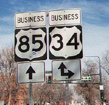
BR 34 then goes two short blocks east to 8th Ave.
There, BR 34 hits BR 85, and is probably one of the
few places in the country where a business route intersects
another business route. Unfortunately, it's not signed that
way. Signs at the intersection only use the 85 and 34
shields by themselves, without any sort of indication they
are business routes. BR 34 turns south along BR 85 to
18th St. That intersection does use shields with the BR
indication, however (picture). BR 34 heads east on 18th, across the US 85 expressway
bypass, then southeast again hooking up with US 34 3.3 miles
east of downtown.
Photo Gallery:
- 10th St/10th Ave Turn.
Westbound BR 34 on 10th St, approaching its right turn onto 10th Ave.
BR 34 goes one short block north then turns west on 9th St, with 10th
and 9th forming a one-way couplet. Photo by Dale Sanderson. (March 2007)
- 10th St Westbound. Westbound BR 34 (10th St) heading away from BR 85 (8th Ave). (March 2007)
- 10th St/8th Ave Signal Signs. Eastbound BR 34 (10th St) at BR 85
(8th Ave). On the signal mast arm is this sign showing BR 34's right
turn. This looks like something cooked up by the city, not CDOT since
the markers within the sign have an odd shape. (March 2007)
- 8th Ave/10th St Turn. Northbound BR 34-85 at 10th Street, showing the signs for BR 34's left turn. Photo by Dale Sanderson. (March 2007)
- BR 34-85 Reassurance Markers.
Northound on BR 34-85 (8th Ave) approaching downtown Greeley. Here
there is this reassurance marker assemply, but the markers have an odd
shape, making me think it was done by the city and not CDOT. (March 2007)
- 8th Ave/18th St Turn. Southbound BR 34-85 at 19th St, with the signs for BR 34's left turn. Photo by Dale Sanderson. (March 2007)
History:
Greeley bypass was constructed from the west split east
to US 85 about 1970, and from US 85 east to the east split
about 1979. Major widening of BR 34 on the west side of Greeley done in the late '00s.
|
|
|
|

Olathe
|
Length*: 1.54mi
N End: Jct US 50 north of Olathe
S End: Jct US 50 south of Olathe
Milepost Guide:
- 0.00: US 50 north of Olathe (begin BR 50)
- 0.93: SH 348/5th St., Olathe
- 1.51: US 50 south of Olathe (end BR 50)
Average Annual Daily Traffic (2008):
- 1300 at north Jct US 50
- 2900 north of SH 348
- 1400 at south Jct US 50
Guide:
The US 50 bypass was
constructed to swing east of Olathe, and then old US 50
through town was given a BR designation. However, I should
note that on CDH maps throughout the 1980s, there was no BR
shown in Olathe. Who was asleep at the wheel in the mapping
department?
BR 50 through Olathe has no
street name, simply "Hwy 50".
History:
US 50 bypass constructed 1977.
US 50 main listing
|
|
|
|
Pueblo
Avondale
|
Length*: 16.94mi
West End: Jct SH 96 at 4th St./Santa Fe Ave. in
Pueblo
E End: Jct US 50 east of Avondale
Places: Pueblo, Vineland, Avondale
Expressway: 5-lane undivided from Pueblo east to Jct SH 231.
Roadway Names: Santa Fe Avenue in central Pueblo.
Milepost Guide:
- 0.00: SH 96, Pueblo (begin BR 50)
- 0.87: On ramp to SB I-25
- 2.30: SH 227/Joplin Ave. east of Pueblo
- 7.38: SH 233 south of Baxter
- 9.44: SH 231, Vineland
- 16.94: US 50 east of Avondale (end BR 50)
Average Annual Daily Traffic (2008):
- 12,100 at SH 96
- 19,700 at I-25
- 23,000 east of SH 227/Joplin St.
- 13,800 east of 21st Ln.
- 7600 west of SH 233
- 3000 east of SH 231
- 920 at US 50
Guide:
BR
50 is odd in the fact that it does not hook up with US 50 on its west
end. BR 50 starts at SH 96 at 4th St. and Santa Fe Ave. in downtown
Pueblo, just west of I-25. It heads south on Santa Fe paralleling
I-25's west side, and then crosses over to I-25's east side near Exit
98, goes over the Arkansas River, and then curves east. US 50 and BR 50
parallel each other (US 50 on the north, BR 50 on the south, the
Arkansas River in the middle) for 15 miles out onto the heavily farmed
plain. As BR 50 is going east, it is a 5-lane undivided expressway
until the SH 231 intersection in Vineland. East of that BR 50 goes
through Avondale then ends at US 50.
Photo Gallery:
- Five-Lane Undivided. This shot on eastbound BR 50 shows its five-lane undivided section east of Pueblo. (May 2009)
- Saint Charles River Mismatched Bridges.
Here BR 50 crosses the Saint Charles River west of Vineland on two
separate bridges. Since the eastbound bridge is newer, it doesn't match
the original through-truss used by the westbound road. (May 2009)
- Avondale. Eastbound on BR 50 as it goes through Avondale. (May 2009)
History:
US 50 Pueblo bypass constructed in 1957.
|

Basalt
|
Length*: 2.41mi
W End: Jct SH 82 west of Basalt
E End: Jct SH 82 southeast of Basalt
Roadway Names: Two Rivers Road
History:
The
SH 82 bypass was completed around the south side of Basalt in 1988, and
BR 82 was run along it former route through town on Two Rivers Road.
According to Terry Carter old SH 82 had a signal in town at Midland
Avenue (Frying Pan River Road), and when the bypass was completed the
signal was removed and turned into a four-way stop. BR 82 was turned
back to local control sometime in 2005-2007.
Photo Gallery:
Main SH 82 listing
|
|
|

Brighton
|
S End: 1950s to 1990s: Jct US 85 at Bromley Lane;
1990s to 2003: Main Street and Denver Street at north city
limit
N End: Jct US 85 at 168th Avenue
Roadway Names: Main Street
History:
The expressway Brighton bypass was in place by 1957. BR 85 at first started at the US 85 expressway on Brighton's
south side at the signalized intersection with Bromley Lane,
and then headed east on Bromley for less than a block. Just
east of US 85, it turned north on Main Street and followed
that north through town to 168th Avenue/Baseline Road. It
then headed back west the few short blocks to US 85.
The section of BR 85 from the south split north
through downtown to the north city limits at Denver Street
was turned back in the late 1990s. The remainder was turned
back in the first part of 2003.
Some maps show a BR 85 going from Brighton all the way
to Fort Lupton. While it's true this was US 85 before the
expressway was built, it is not state-maintained, instead it
is Weld CR 27.
US 85 main listing
|
Fort Lupton
|
Length*: 1.77mi
S End: Jct US 85 interchange at SH 52 in west Fort
Lupton
N End: Jct US 85 at 14th St. in north Fort Lupton
Roadway Names: Denver Avenue
Average Annual Daily Traffic (2008):
- 14,600 on SH 52 east of US 85
- 7200 north of SH 52
- 4200 at north Jct US 85
Guide:
BR 85 starts at the US 85-SH 52 diamond interchange,
heads east on 1st St. (SH 52) to Denver Ave., and there
turns north. It goes north on Denver Ave., then at 14th St.,
hits the US 85 expressway again, ending at a signalized
intersection with it.
History:
US 85 expressway bypass of Fort Lupton was in place by
1957. The interchange at US 85/SH 52 was put in about 1976.
|
|
|
|
Platteville
|
Length*: 2.69mi
S End: CR 28 south of Platteville
N End: Jct US 85 north of Platteville
Roadway Names: Main Street
Average Annual Daily Traffic (2008):<> 1200 north of SH 66
Guide:
BR
85 starts along the US 85 west frontage road at CR 28 south of
Platteville. It then heads north into town, coming on to Main Street.
At Justin Ave it has an intersection with SH 66, then continues north,
ending at US 85 on the north side of town. Coming south on US 85,
turning off onto BR 85 is like taking an exit ramp.
It should be noted northbound on mainline US 85, the
Platteville business route is signed as departing from US 85 by turning
left at SH 66. There's no advance signing of the business route at the
CR 28 intersection.
History:
US 85 expressway bypass of Platteville
was in place by 1960. However, it appears that it wasn't until sometime
in the 2007-2009 time frame that the section of Main Street south of SH
66 was officially logged as part of BR 85. |
|
|
|
Greeley
|
Length*: 4.57mi
S End: Jct US 34-85 between Greeley and Evans
N End: Jct US 85 north of Greeley
Expressway:
- From US 85 north through Garden City into
Greeley.
- From north end of Greeley north to US 85. Includes an
interchange at US 85.
Roadway Names: 8th Avenue
Average Annual Daily Traffic (2008):
- 8900 north of US 34-85
- 18,300 south of 20th St.
- 15,700 on BR 34-85 south of 16th
St.
- 9400 north of 9th St
- 5700 at north Jct US 85
Guide:
BR 85 starts at an interchange on the south side of
Greeley, though parts of the interchange fall within the
towns of Greeley, Garden City, and Evans. Continuing north
on BR 85 from US 85 is the through movement, with no
ramps required. BR 85 then goes north and warps down to
an urban arterial onto 8th Ave., and has a multiplex with BR 34 from 18th to 10th streets. BR 85 goes right through
the heart of Greeley on 8th Ave., then again hits the US 85
expressway again north of town. That is at an interchange,
but is only a partial interchange. Again, taking the BR is
the through movement, but if you're coming south on US 85
and want to use the bypass, you need to take a sharp ramp to
the right, then a narrow flyover bridge to the left.
Photo Gallery:
- 8th Ave Southbound. Southbound on BR 85 (8th Ave) coming into downtown at 8th St. Photo by Dale Sanderson. (March 2007)
- 8th Ave Northbound. Another shot on BR 85, looking north just north of 10th St. (March 2007)
- 8th Ave/10th St Turn. Northbound BR 34-85 at 10th Street, showing the signs for BR 34's left turn. Photo by Dale Sanderson. (March 2007)
- BR 34-85 Reassurance Markers.
Northound on BR 34-85 (8th Ave) approaching downtown Greeley. Here
there is this reassurance marker assemply, but the markers have an odd
shape, making me think it was done by the city and not CDOT. (March 2007)
- 8th Ave/18th St Turn. Southbound BR 34-85 at 19th St, with the signs for BR 34's left turn. Photo by Dale Sanderson. (March 2007)
- BR
85/BR 34. Marker assembly on northbound 8th
Avenue at 18th Street, Greeley. (January 1999)
History:
US 85 expressway bypass of Greeley, with interchanges,
was in place by 1964.
|
|
|
|

Mancos
|
Length*: 2.49mi
W End: Jct US 160 west of Mancos
E End: Jct US 160 east of Mancos
Roadway Names: Grand Avenue
Milepost Guide:
- 0.00: US 160 west of Mancos (begin BR 160)
- 1.45: SH 184/Main St.
- 2.49: US 160 east of Mancos (end BR 160)
Average Annual Daily Traffic (2008):
- 700 at west Jct US 160
- 1800 west of SH 184
- 530 at east Jct US 160
Guide:
This is a simple one. A US 160 bypass of Mancos was
built to pass to the north of town. BR 160 was put down
old US 160's route down Grand Ave.
History:
Bypass constructed about 1972.
US 160 main listing
|
Bayfield
|
Length*: 2.44mi
W End: Jct US 160 west of Bayfield
E End: Jct US 160 east of Bayfield
History:
US
160 had a bypass constructed about 1972 around the north side of
Bayfield and the former route through town was given the business
designation. CDOT turned back the business route to the town in summer
2011. |