|


|
Length*: 0.33mi
NW End: Traver Trail in Glenwood Springs
SE End: Jct SH 82 at Laurel and 6th Streets in
Glenwood Springs
How Marked: Not marked
Average Annual Daily Traffic (2008): 12,600
Guide:
This starts on the I-70 north frontage road in the
northwest part of Glenwood Springs, then heads southeast
into the central part of town. At Laurel and 6th Streets, it
hits SH 82, which from I-70 Exit 116, comes north on Laurel,
turns east on 6th, then south on Grand Avenue to head toward
Carbondale. The street name for the road that Spur US 6 is
on is called "Highway 6-24", even though it hasn't been part
of US 6-24 for decades.
History:
Old US 6 alignment before I-70 was built. Been on the
books since at least the 1970s. I-70 was completed through
there about 1971.
Main US 6 listing
|
|
|
Length*: 0.74mi
N End: Jct I-70 Exit 11 south of Mack
S End: Jct US 6 at Mack
History:
Probably put into place about 1972 when I-70 was
completed westward from Grand Junction to Mack. I-70 was not
finished from Mack into Utah until 1973, so before that
traffic got off there, went north on the spur connection,
and followed old US 6-50 from Mack west to Utah. In 1975,
old US 6-50 west of Mack was turned back, and the spur
connection became part of the main route of US 6.
|
|
|
|
|

|
Length: ~0.4mi
S End: Jct I-70 Exit 90 south of Rifle
N End: Jct US 6 at in Rifle
How Marked: Probably just as regular SH 13
History:
This one was added about 1977 when I-70 was completed
past Rifle. It started at US 6 in the central part of town,
and headed south across the Colorado River to I-70, ending
at the diamond interchange at Exit 90. Sometime between the
1970s and 1996, it was made a regular part of SH 13, instead
of a spur connection. Not that it ever made any difference
either way to the normal traveler.
Main SH 13 listing
|
|

|
Length*: 0.55mi
SW End: Jct US 24-40-287/SH 40 west of Limon
NE End: Jct I-70/US 24-40-287 Exit 359 northwest of
Limon
How Marked: As a mainline BL I-70/US 24-40-287
Expressway: Entire length
NHS: Entire length. US 24 is NHS coming northeast
from Colorado Springs, and this is how it gets to I-70.
Average Annual Daily Traffic (2008): 5200
Guide:
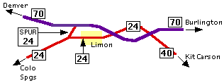
This is definitely an interesting one. The thing that
makes it hard to explain is that commercial maps are almost
no help, because things tend to be in close quarters there
around Limon. The short story is that Spur US 24 goes from
the US 24-40-287 mainline west of Limon northeast out to
I-70 Exit 359. But, there's a lot more to the story than
that. So, I have here a few homemade maps to help explain
things.
This first map here shows the routes in and around Limon.
The numbers inside the squares are the official State
Highway numbers that CDOT has given to the route in
question. A route cannot have more than one S.H. number, and
no distinction is made between state, US, and Interstate
highways, so that's why I use squares. SH 71 and SH 40 are
omitted for clarity.
This next map shows what signs out in the field have the
roads marked as. Note that from the intersection west of
Limon, you have US 24 going in three directions from it.
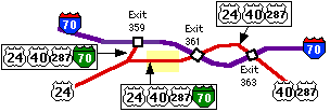
As you can see, Spur US 24 is actually marked with four
routes, US 24, US 40, US 287, and BL I-70.
History:
It was built as a new highway on a new alignment when
I-70 was completed through there in 1975. It was needed to
get traffic from the west side of Limon back out to I-70.
Previously, old US 40-287 went northwest from Limon via what
is now SH 40, northwestward from the intersection at the
south end of Spur 24. See SH 40
for more.
Suggestions:
Too confusing having all those routes around Limon.
Here's my suggestion for how things should be marked:
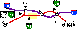
It could be easily accomplished by simply removing the US
40-287 signs west of Exit 363, and the US 24 signs from
Limon east.
Main US 24 listing
|
|
|
|
|

|
Length*: 0.93mi
SW End: Jct US 34 east of Brush
NE End: Jct I-76/US 6 Exit 92 northeast of Brush
How Marked:
- On I-76 mainline: US 6-34, Brush-Yuma
- At bottom of I-76 ramps: To US 34/SH 71, Brush-Akron-Yuma
- On eastbound US 34: To I-76/US 6
- On westbound US 34: To I-76/US 6, Sterling
- On westbound US 6: To US 34/SH 71, Brush
- On northbound spur: BL 76/Spur 34/To I-76
- On southbound spur: BL 76/Spur 34/To US 34
Average Annual Daily Traffic (2008): 2200
Guide:
Spur 34 goes from US 34 east of
downtown Brush northeast along the BNSF rail line to I-76
Exit 92. That exit is the same place US 6 reappears from I-76
and heads northeast parallel to it on I-76's northwest side,
via Hillrose and Atwood to Sterling.
Photo Gallery:
- North End, To 34/West BL 76. The first markers one sees on southbound Spur 34 south of I-76. (May 2005)
- North End, West Spur 34.
Immediately after the markers above appears this one. It features
"SPUR" in tiny lettering and marks the spur as an east-west route like
US 34, even though the spur itself is oriented north-south. (May 2005)
- South End, BL 76/Spur 34. The markers on northbound Spur 34 just north of US 34. Again there is "SPUR" in tiny lettering. (May 2005)
History:
This actually was originally part of US 38, then
US 6. When I-76 (I-80S)
was put through about 1965, US 6 was moved into hidden status from Exit
92 westward, leaving a stub from Exit 92 south to US 34. So the stub
was made as a spur connection of US 34. Main US 34 listing
|
|
|
|
|

|
Length*: 0.36mi
E End: Jct US 36 interchange at Baseline Rd. and 28th
St. in Boulder
W End: Jct SH 93 at Baseline Rd. and Broadway in
Boulder
How Marked: As "To SH 93/Baseline Road" on US 36
Average Annual Daily Traffic (2008): 30,800
Roadway Names: Baseline Road
Guide:
You wouldn't even know this one existed if it weren't
for the CDOT route logs. It goes from the interchange at the
northwest end of the Denver-Boulder Turnpike (28th St. and
Baseline Rd.) west along Baseline for about three blocks to
Broadway (SH 93). That area is just one long string of
stoplights, and the intersections and ramp ends all just
blend into each other.
Main US 36 listing
|
|
|
|
|

|
Length*: 1.49mi
E End: Jct SH 78 southeast of Beulah
W End: Intersection of Grand and Pennsylvania Aves.
in Beulah
How Marked:
- On WB SH 78: Business 78
- On EB SH 78: 78 West
- At Endpoint: End 78 and East 78
Average Annual Daily Traffic (2008): 710
Roadway Names: Grand Avenue
Guide:
Spur
SH 78 starts at a triangular intersection with SH 78 just adjacent to
the Squirrel Creek/Middle Creek confluence east of Beulah, then heads
north and curves west, going onto Grand Ave. in Beulah. In town, it
ends at the intersection with Pennsylvania Ave a block past the town's
gas/general store. Note that even though a sign on SH 78 calls this a
business route, it is defined as a spur route by CDOT.
Photo Gallery:
- Westbound Spur Route. Westbound on Spur 78 coming in to the main part of Beulah. (May 2009)
- End Spur 78. The sign at Pennsylvania Ave marking Spur 78's end. (May 2009)
- Begin Spur 78. Looking back east. Note the sign say "east" rather than spur or business. (May 2009)
History:
The road from SH 76
(now SH 78) into Beulah was brought onto the state payroll
about 1939 but was designated SH 243. About 1954
SH 76 was truncated and actually routed up the spur so its west end was at Beulah. SH 76 was extended
southwest back to SH 165 by 1956, creating this
Spur for the road into Beulah. Spur 76 then became Spur 78 when SH 76
was renumbered to SH 78 to avoid conflict with I-76 in 1975.
Main SH 78 listing
|
|

|
Length*: 0.31mi
SE End: Jct SH 83 in north Colorado Springs
NW End: Jct I-25 Exit 150 in north Colorado
Springs
How Marked: As "To SH 83 Academy Blvd" on I-25; As
"To I-25" on SH 83
Roadway Names: Academy Boulevard
History:
While SH 83 used Academy Blvd southward through Colorado Springs, this spur route served as a connection between SH 83 and I-25 Exit 150 on the north side of town. Spur 83
was turned back October 1, 2007 at the same time the rest of SH 83 in
Colorado Springs was (although it took several months for signage to
change).
Main SH 83 listing
|
|

|
Length*: 0.18mi
SE End: Jct SH 109 at 3rd St and Adams Ave in La
Junta
NW End: Jct US 50 at 1st St and Bradish Ave
How Marked: "TO SH 109" on US 50; "TO US 50" on SH 109
Average Annual Daily Traffic (2008):
- 5300 on 3rd St. west of SH 109
- 2200 on Bradish Ave. south of US 50
Guide:
SH 109 has a bridge taking it over the
Arkansas River and a BNSF rail line, and the approach of that bridge causes it to
go over US 50 rather than intersect it. Consequently, there
needed to be a spur connection put in between the foot of
the bridge and US 50. The connection goes from the foot of the SH 109 bridge at 3rd
and Adams, west along 3rd one block to Bradish, then two blocks north to US 50.
Photo Gallery:
History:
Prior to the present SH 109 bridge, SH
109 intersected US 50 at Bradish Ave and headed north under a railroad
underpass. The current bridge SH 109 takes over the Arkansas, railroad
and US 50 was built in 1967, creating the need for the connection
between the foot of the bridge at Adams Ave/3rd St and US 50 on 1st
Street. However, at the time the bridge was built SH 109 headed south
through La Junta on Colorado Ave, 10th St and San Juan Ave, so the spur
connection most likely was only from 3rd to 1st on Bradish. SH 109 was
rerouted onto Adams Ave southward out of town in the 1980s or early
'90s, and the spur connection extended another block eastward to 3rd
and Adams. Main SH 109 listing
|
|

|
Length*: 1.95mi
W End: Jct SH 110 in northeast Silverton
E End: Mayflower Mill
How Marked: Unknown
History:
SH 110 is an original 1920s highway. At first, however,
mainline SH 110 went from US 550 up the route of this spur,
ending at Howardsville. Eventually by 1963, mainline SH 110
was rerouted to go north to Gladstone, and this spur was
created to go from SH 110 on the north side of town east to
the Mayflower Mill, a mining structure. The two legs of SH
110 existed up to mid 2003, when almost all of SH 110 was
turned back, including this spur route.
Main SH 110 listing
|
|
|
|
|

|
Length*: 0.32mi
NW End: Jct SH 119 north of US 6 in Clear Creek
Canyon
SE End: Jct US 6 east of SH 119
Average Annual Daily Traffic (1996): 10,200
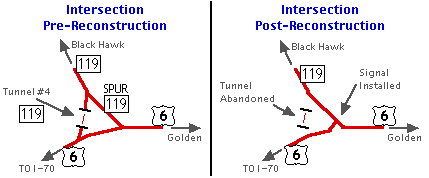
History:
The US 6/SH 119 intersection used to be "triangular",
with US 6 going east-west, SH 119 going north, and then
Spur SH 119 creating a leg going northwest-southeast.
The intersection is used heavily by traffic going from
Denver up to gamble in Black Hawk and Central City.
There was a project at the SH 119/US 6 intersection in
1998 which turned it into a standard T intersection with a
signal light. Spur SH 119 became part of mainline
119. Here's a map:
Main SH 119 listing
|
|
|
|
|

|
Length: 0.31mi
N End: Jct SH 128 at Federal Blvd. and 120th Ave. in
Westminster
S End: Jct US 287 in Westminster
Roadway Names: Federal Blvd.
Guide and History:
Spur SH 128 was due to how US 287 curved at the
120th/Federal intersection. US 287 went from west on 120th
to south on Federal, and curved with a pretty big radius, so
from the very north end of the curve, SH 128 headed due east
from it along 120th. The spur connection went south along
Federal Blvd. from 120th south to the very south end of the
US 287 curve.
However, at some point in time, the curving US 287 was
turned into a roadway for southbound traffic only, so
northbound US 287 traffic had to go north on Federal to
120th and then turn left at a signal light. As a result,
Spur SH 128 was no longer needed because it was now
part of mainline US 287. Karl Williamson reports this was done in the 1980s or '90s.
Here's
a picture on the curving ramp of US 287, showing a
bridge with the now-unused northbound lane on the left side.
Main SH 128 listing
|
|
|
|
|

|
Length: ~6mi
W End: Jct SH 145 west of Telluride
E End: Idarado Mining Company Mill southeast of
Telluride
How Marked: According to Ed Wilson, the intersection
west of Telluride is marked only with signs indicating what
towns are which way.
History:
This route was actually originally SH
108, but sometime about 1955 it was renamed
as a spur of SH 145. Personally, I would not have seen
anything wrong with it remaining SH 108. Spur SH
145 existed up through about 1995, when it was turned
back.
Main SH 145 listing
|
|
|
|

|
Length*: 0.20mi
E End: Jct SH 196 at Main and 7th Sts. in north
Wiley
W End: Jct US 287 northwest of Wiley
How Marked: On southbound US 287 with a "<- Wiley" sign; not marked on northbound US 287; unknown on SH 196
Roadway Names: 7th Street
History:
SH 196 had a funny little jog in it at Wiley. It crossed
US 287 then turned north on Main St, then at 7th St turned
east. From the intersection of Main and 7th, Spur SH 196
was run from there out west the short 0.2mi to US 287. This was in
place from 1957 until SH 196 east of US 287 was turned back in early
2010. Main SH 196 listing
|
|

|
Length*: 1.15mi
W End: Barricade west of BR 34
E End: Jct BR US 34 west of Greeley
How Marked: One "SPUR 257" street name sign
Annual Average Daily Traffic (2008): 1200
Guide:
Despite
being Spur 257, this roadway doesn't actually connect to SH 257. The
west end of Spur 257 used to connect to SH 257 north of BR 34 and
provided a shortcut for traffic going between Windsor and Greeley.
However, the intersection with SH 257 was closed and barricaded off,
making Spur 257 end at a dead end, with its only connection now at its
east end with BR 34.
History:
When it was still accessible
from SH 257, coming south Spur 257 was signed simply as "<-
Greeley". On BR 34, going from westbound BR 34 onto Spur 257 was just
like taking a ramp off to the right, and could be done at 55mph.
However, after its west end was barricaded off, the east intersection
also ended up being realigned to a right angle in conjunciton with the
building of Promontory Parkway.
The west end of Spur 257
was barricaded off in mid-2002. Other projects had taken place in the
area including the BR 34/SH 257 interchange, making for a better route
for traffic to take instead of the spur. It at first appeared CDOT had
abandoned all of Spur 257, but subsequent looking at CDOT data made me
realize it was still on the CDOT system.
Photo Gallery:
- Spur
SH 257 Sign. This sign was new as of Spring 1999, but disappeared when the west end was barricaded.
You can see "SPUR" in very small letters
above the numbers, while "257" is smaller than normal. I
know of no other signs in Colorado like this. On the left
side of the picture you can see an "Either Side" sign,
with westbound BR 34 curving off to the left.
Main SH 257 listing
|
|

|
Spur Connection 1
Length*: 0.030mi (1 block)
S End: Jct SH 279 at Spring and Gregory Sts. and in
Central City
N End: Jct SH 279 at Spring and Lawrence Sts. and in
Central City
Average Annual Daily Traffic (1996): 3100
Spur Connection 2
Length*: 0.027mi (1 block)
S End: Jct SH 279 at D and Gregory Sts. and in
Central City
N End: Jct SH 279 at D and Lawrence Sts. and in
Central City
Average Annual Daily Traffic (1996): 1100
How Marked: Was no signing.
Notes:
Both of these went in between the two one-way streets
(Gregory and Lawrence) that carried SH 279 in Central
City. SH 279 was turned back sometime in the late
1990s, so the need for these two spur connections
disappeared.
Main SH 279 listing
|
|

|
Length*: 0.24mi
NW End: Jct US 491 at Pi�on Dr. in Cortez
SE End: Jct US 160
How Marked: As "East 160 Durango" on SB US 491; as "North 491 Dove Creek" on WB US 160
Average Annual Daily Traffic (2008): 5400
Roadway Names: Pi�on Drive
Guide:
The US 491-160 intersection in west Cortez is another
"triangular" intersection. US 491 goes north-south, US 160
east from US 491, and Spur US 491 forming a leg that goes
northwest-southeast.
Main US 491 listing
Related Site: Historic US Highway Ends in Cortez by Dale Sanderson
|